Category «Pedestrian»

Ohio Street Rain Garden
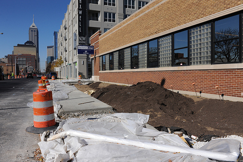
A couple of weeks ago, Mayor Greg ballard announced a green infrastructure project which would be located on Ohio Street in downtown. The stretch of sidewalk to be improved (and in this case, improved is the proper term) is between College Ave, and Park Ave. This is the same block that contains the newly, and …
What Indy could learn from Glendale, CA and its Parking Plan
As we move closer to a final decision by the Indianapolis City-Council and the public learns more about what the deal could mean for the region’s long term parking meter reality, a constant light needs to be shined so that we can all stay current. I read a really good op-ed by local political blogger …
Indianapolis Cultural Trail Northeast Corridor – Before and After, Pt. 3
In recognition of the completion of the Indianapolis Cultural Trail’s Northeast Corridor, Urban Indy is running a series of comparison shots to show you how this project has transformed our city streets. Today we’re featuring three pairs of photos from one of the more interesting features of the Northeast Corridor. For most of its run, …
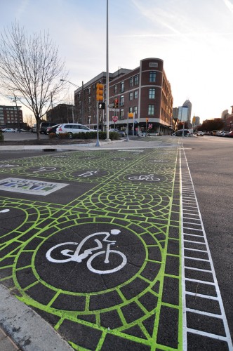
Midtown Indy Complete Streets Project Plans

If you follow this website, you undoubtedly are familiar with the term “complete streets”. Complete streets is a term that refers to a total consideration of the transportation cross section when planning a new infrastructure related project. Put more eloquently, “Complete streets are designed and operated to enable safe access for all users. Pedestrians, bicyclists, motorists …
Indianapolis Cultural Trail Northeast Corridor – Before and After, Pt. 2
In recognition of the completion of the Indianapolis Cultural Trail’s Northeast Corridor, Urban Indy is running a series of comparison shots to show you how this project has transformed our city streets. Today we’re featuring three pairs of photos from an area of Massachusetts Ave. commonly referred to as the East End.  This is the area …
Indianapolis Cultural Trail Northeast Corridor – Before and After, Pt. 1
The Cultural Trail Northeast Corridor construction is finally (mercifully!) coming to a close this Friday, November 5. After 19 months of work and a few headaches along the way, a ribbon cutting ceremony will take place at 5pm on the southeast corridor of Massachusetts Ave. and Park Ave.  That’s First Friday on Mass Ave. and …
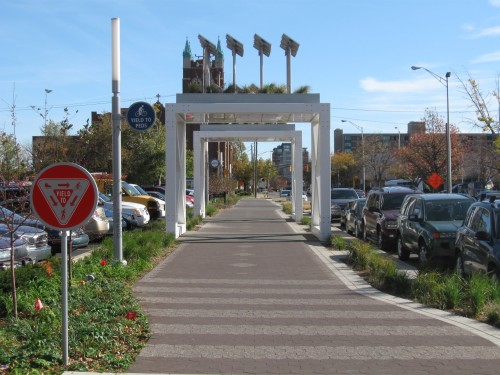
The New Georgia Street: An Urban Design Crit.
In case anyone hasn’t noticed, Georgia Street in downtown Indianapolis is currently getting an extreme makeover and turning large portions of its right-of way over to the pedestrian. Â Announced in early May of this year, this project has been touted as the latest example of Indianapolis taking positive steps in turning their downtown into a …
Multi-use Path coming to E. 62nd Street
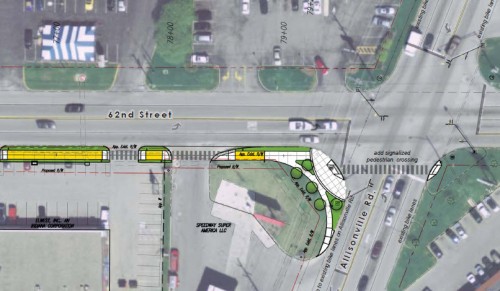
The DPW has a new non-automobile oriented multi-use path planned along 62nd street. The path once completed, will start and end at Keystone Ave and Allisonville Rd. It will also facilitate a safe path from Allisonville Road’s bike lanes across to Keystone and once restriped, down bike lanes that will be painted along Broad Ripple …
Connecting Fountain Square to Broad Ripple
Currently, College Avenue is a one way northbound street between Virginia and Massachusetts Avenues. There have been a few public calls to change this missed connection, and to return College into a two way street (which even has its own facebook fan page, which I have joined). There are also calls to instill bike lanes …