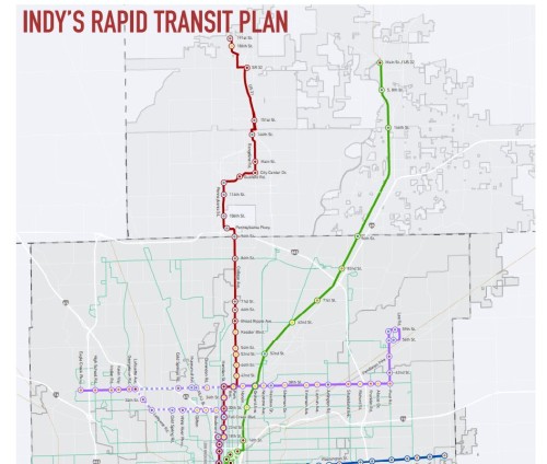
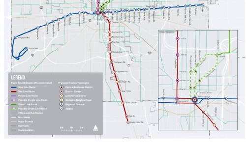
Indy’s Plan2020 has posted a link to an updated version of the proposed Red Line between Westfield and Greenwood. That’s right, Westfield, who’s mayor has been a consistent supporter of transit, is included in the newest configuration. Here’s the latest map (shown in 20 parts)
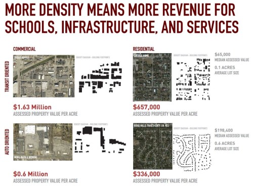
There’s more information out there, including this pdf which is meant to be seen in poster form. The boards are currently on display in the Old City Hall, along with 8 other locations around town. I particularly like the second board, which lays out the economic data that supports the need for Transit Oriented Development in Indy:
The Plan2020 website also contains links to 2 large documents with a good deal of supporting data. The first is the Transit Oriented Development Strategic Plan,  which deals with the potential for the entire Indy Connect build out. The second document is the Red Line Station Area Info Sheet, which lists pluses and minuses for some of the stations, and includes some eye-catching graphics. This is truly a document meant to appeal to the transit geek, which I know are out there in Urban Indy’s readership.
Feel free to comment here about this plan, as well as anything specific that you may have found interesting.


That property value per acre graphic says it all.
Also, I’m a little surprised 49th and College was excluded but 46th and College was included. Not much going on at that corner.
The 46th Street bus connects with the Castleton bus, while 49th Street has no bus service. There is some decent potential at each corner, but I’m guessing that was the number one deciding factor.
I think Kevin’s right that local bus connection was the critical factor. Also, BRT station spacing matters. It’s arguable that they shouldn’t have stations at both 52nd and 54th. If they also put a station at 49th, we’d have three stations within about a half mile, which is too many.
Despite being a difference of three between 46th and 49th, the effective distance is actually closer to 2 Indy blocks. That puts 49th within a 1/4 mile walking radius of the station at 46th, so it’s still pretty well served.
Also… if a location is already active, adding a stop can make traffic patterns more congested. I believe that is the reason for putting the stop at Park and 38th rather than right at College and 38th.
Man, does Charles Marohn know they ripped off his graphic?!? 😉
In any case, those are definitely the most interesting types of charts and it really is amazing when I talk to people from the burbs about this stuff, they really don’t get the gravity of the value of land use. And really, transit isn’t the half of it. The extra cost associated with water/sewer, roads, etc is just crazy.
I had the same thought regarding Marohn/Strong Towns. I love it when people can boil down complicated topics in a way that makes sense for the masses.
Is it possible the Red Line Station Area Info Sheets are still out of date? Last meeting I was at (in June) they were talking about a single stop at Park/38th vs. separate stops at Central and College… If/when this is updated, please change “historic Watson McCord neighborhood” to Historic Watson Park neighborhood (we received our historic status – note name change – in 2012).
Oh, sorry… lost track of what website I was on. I will submit that feedback elsewhere! 🙂