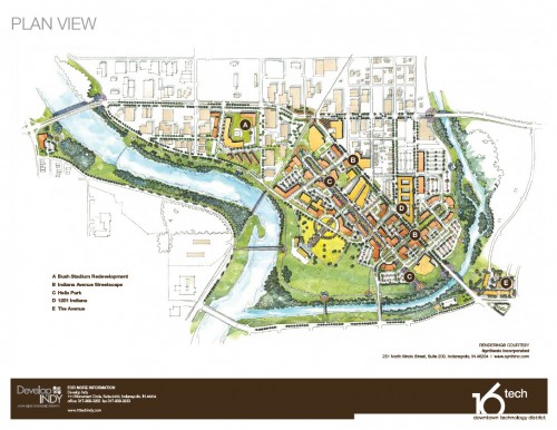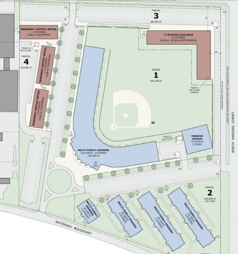
The week of June 13th was an exciting one in Indianapolis. The Broad Ripple Parking Garage was announced. CIRTA launched a campaign to build a transit coalition to present to state lawmakers. And the City announced the 16 Tech Technology district that would be anchored by a redeveloped Bush Stadium. On the surface, the 16 Tech proposal looks like a positive one. An underdeveloped neighborhood with a culturally rich past gets a boost from the city while urban thinking residents are appeased by the presence of pedestrian and bike friendly infrastructure.
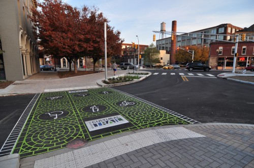
Indeed, The Technology Trail should be a fantastic addition to what is currently a very dead stretch of road. The addition of a linear park will also be welcome; throw in storm water retention in a quasi-natural method and urbanists have one foot through the door in supporting this. Additionally, a long-time decrepit structure is repurposed with medium (low?) density residential and greenspace to boot. However, upon further examination, I have a few questions that would make THIS urbanist feel better about the proposed development. Melissa Todd with Develop Indy was kind enough to answer some questions for me.
Q:What will happen to IUPUI owned parking lots? How does the city plan on using space that is already used by IUPUI for off-campus parking as well as Herron School of Art facilities?
A:We have worked closely with all levels of IUPUI, IU, & IU Medical School in the development of this plan, and they are very supportive of both the overall concept and the specific elements. The Herron building will undergo a major expansion this fall that will include the IU building immediately to the north. We have worked with the IU in house architect to coordinate this expansion with the Indiana Streetscape work. In the short term the existing IU parking lots will remain
Q:Will IndyGo shelters be “spruced up” and/or covered to fit in with the new design?
A: We anticipate new Indy Go shelters and planned for them along Indiana Avenue in the plan. It is further anticipated that the design of these shelters would be different to fit into the general theme of the project.
Currently, transit only makes a cursory visit to the proposed tech district area. This is likely due to the fact that there is really nothing there now. The 5 bisects the district and offers great service between downtown and the 16 Tech area. Also, the 25 & 10 offer walking distance stops for potential visitors and residents to get to and from the area. However, I was let down when I read Develop Indy’s brochure, and the only mention of public transportation came in the form of the Clarian (now IU Health) People Mover. Those of you who are locals know the laughable status of that service. Why would Develop Indy mention this limited and out of the way service, yet fail to mention IndyGo or local transit at all? Being located to the most dense concentration of employment of jobs in the entire state should merit at least a mention, but nothing. Perhaps a nice shelter for the 5 route at 16th & Montcalm St will match new streetscape? With the addition of 1201 Indiana, and The Avenue, transit boardings are likely to get a boost in this corridor.

Q: Will the Technology Trail ever connect with the Cultural Trail?
A: The two trails were designed to complement one another and it is certainly possible, based on the current design and would be welcomed, but no decision has been made about this.
Q:Helix Park does not get a specific mention in regards to when potential construction could begin. Is there a plan for this or is it included with the streetscape?
A: The plan is for Phase I of Helix park to start construction in 2013, and the City will own the land for this section of Helix park when construction starts. The entire area is currently being rezoned by the City. Tamara Tracy is the principal planner for the City on that effort.
Q: According to google maps overhead view of the focus area, there are currently a glut of industrial uses and/or vacant land. How are the owners of this land going to be compensated?
A: We will work with land owners to acquire additional property as the development progresses. There are no plans to exercise eminent domain.
Q: Is there some sort of master parking plan being developed to handle increased parking demand once developers start building in this location?
A: As the project progresses in the development cycle structured parking will be encouraged and required, which will be covered in the rezoning documents.
Q:Public transit does not receive much of a mention in the Develop Indy literature/brochure. Is there any thinking about how to further promote usage of IndyGo to future residents and business tenants?
A: The plan was centered around the concept of more convenient connections of all types: walking, biking, and mass transit. We contemplated and planned for the possibility that one day IU Health may want to extend the monorail system through Helix Park. We are talking to IPL about electric plug in station in the development.
Q: Is there a plan to relocate the long line of tall utility poles that are located on Indiana Ave? They seem unsightly and if the streetscape is aiming to beautify, I could see them being relocated underground or something like that.
A: The utilities will be buried north of Milburn Ave along Indiana Ave.
As I mentioned before, Helix Park looks to be an innovative and gravitating public space that is currently taken up by an industrial space and a freight railroad spur to the CSX line which also bisects the 16 Tech district. How could the CSX railroad have been utilized to further sell the district? Indyconnect’s long term future paints a line directly through here on the map as a means of running rail transit to the far NW metro area. Perhaps in the future, frequent service could be offered to the 16 Tech district by means of this railroad. But that is getting ambitious.

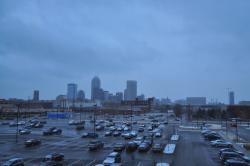
Taken as a whole, there are still a lot of unanswered questions. In addition, the videos, animations and renderings for this district look nice. However, and as I always seem to gravitate towards, transit never got a mention and I wonder how the dense renderings provided will ever be achieved without a large amount of automobile parking devoted to it by way of a parking garage or surface lot. One can already see that there are nearly 500 parking spaces planned with the Bush Stadium renovation. While I am pleased to see an otherwise underutilized area of downtown get pushed to the forefront, it pains me to see a disconnect between land-use and transit. If Indyconnect’s vision ever comes to fruition, perhaps demand for parking can be lessened in this area and developers of future parcels will recognize this. For the time being, this urbanist isn’t 100% sold. Let me be clear, I WANT 16 Tech to succeed, I just hope that we have learned enough to avoid this….

They certainly aren’t learning very fast. Have you seen the new parking lots north and south of Market at Alabama? Also, there is a huge new parking lot going in at South and Delaware. All surface.
I hold out hope that with better transit, even more frequent buses, that parking requirements might be lessened and we can stray away from our addiction to expensive parking lots. I’ve seen places where good transit service squashes this and unfortunately we aren’t over that hump yet here.
I would offer that surface parking is just an interim place holder for future development in some of these cases. With parking structures costing 3x a surface lot, it seems they’re aiming in the right direction to include it in the zoning such that it can be leveraged within the cost of development and not a standalone investment. Only time will tell…
Parking structures cost 3x a surface lot unless it’s Broad Ripple, then it’s 10x.
If anybody’s curious to look back, this 16 Tech plan draws a lot of cues from the a document called “Framework for a Research Community” that was produced in 2003, right around when the Biocrossroads initiative was getting off the ground.
(I can’t seem to get this comment to post with the link in it, so just google “framework for a research community indianapolis” if you’re interested)
The plan mentions a full loop of the People Mover on p20 (and others). At this point, I think it would take a miracle for that to happen. Most glaringly, the point-to-point system they’ve built would require that all the walkway connectors at the terminus stations be completely rebuilt like the Canal Station to accommodate trains moving THROUGH instead of stopping and going back the other direction.
If they could make the system a complete loop, that would help the system immensely. A point-to-point w/o passing zones can only have as many trains as there are tracks. whereas a loop can have as many trains as you want. Put more trains on, the headways improve.
Interestingly, the $4M Indiana Ave. infrastructure upgrade that the city did back in 2007-08 was supposed to include a People Mover station in the 16 Tech area. Poof, never happened.
This is definitely re-packaged “framework for a research community”. It got new life when the City decided to sell the water utility to Citizens…why would they need the old Water Company headquarters on Waterway any longer? So the core of the development property (Bush Stadium plus water company site) already belongs to the city, and a lot more of it belongs to IUPUI.
.
However, the environmentalist in me must note that this area is right on top of one of the city’s key drinking-water aquifers where there are numerous high-capacity wells. Infiltrating runoff water polluted with automotive chemicals may not be the greatest idea. Putting biomedical research labs on top of a drinking-water aquifer will require an extra level of everyday safe-handling protocols. It will also introduce an extra risk in the event of a catastrophic occurence (explosion or fire) that breaches containment systems. I’m not saying we shouldn’t do these things…I’m saying we should do them with appropriate protections for our drinking water.
Chris, it is interesting that you mention the water issue. There was a filing for rezoning today and there was A LOT of information included. It specifically touched on the water issue and laid out what a prospective developer would have to conform to in accordance with the zoning. It sounds like someone consulted you on the topic for the rezoning. 😉
.
It seems like the city did it’s homework when it put together the backbone of this plan. We may not all be super happy with it, but there are some good things in the report such as 1 parking space maximum per dwelling. Lets hope they adhere to things such as that….
Curt, it’s not just me. DMD Planning staff started a community working group on groundwater protection issues in 1993, and they’ve been paying attention to what experts and citizens say.