That most American cities suffer from a plethora of one-way streets is a blog topic in and of itself. After all, just last week I revealed on my personal blog how Houston’s vast downtown only has five streets with two-way sections, and not one of these streets completely transects the city center. The desirability of one-way versus two-way is an argument I’ll save for a later point, when I’m better prepared to identify the streets in downtown Indy that are the top candidates for a conversion. No doubt we can all think of that one irritating block where we can never turn the way we want to go.
But what about the civil engineering necessary in order to make the existing one-way streets feasible? Not every major street can switch from two-way to one way with the simple wave of a magic wand; typically, the entire point of converting a street to one-way is to aid in the flow of higher-speed traffic at the busiest times, allocating more lanes to improve Level Of Service during high-volume periods. But if a street already features numerous traffic lights and requires a stiff 90-degree turn in order to gain access, the one-way standards are not going to make a huge difference at improving the LOS. More often than not, transportation engineers enhance these one-way streets with higher maximum speed limits, gentle turn radii, constrained on-street parking, and timed traffic signals, so motorists don’t have to stop at every intersection. Just as a railway avoids right angles because a train cannot negotiate the curve at a high speed, most one-way streets split from a two-way arterial using as gentle of an angle as possible.
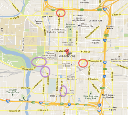
I can think of multiple examples where these “access spurs†exist in downtown Indy. The map below circles a few of them, in either red or purple; for the sake of brevity, I will only focus on the two in red, which seem the most problematic.
Let’s start with the one in the southeast quadrant, where a one-way, eastbound Maryland Street merges with a one-way, westbound Washington Street just to the west of Alabama Street. From the New Jersey Street intersection and westward, Washington Street is two way. But this wasn’t always the case: I have vague memories of a time when both Washington and Maryland were both two-way streets, as recently as the 1980s and even into the early 1990s. During the construction of White River State Park on the west side of downtown, engineers rerouted Washington Street into the serpentine design we use today; as most readers no doubt know, the pedestrian-oriented sculpture garden that links to Indianapolis Zoo forms the historic bridge for Washington Street and the National Road (U.S. 40). Concurrent with the construction of the curvy bypass, traffic engineers converted Washington Street’s divergence at Maryland into a pair of complementary one-way streets. Prior to this point in time (as confirmed by historical maps), Maryland Street terminated at Alabama, since the railroads and heliport prevented it from continuing eastward. But, upon converting Washington and Maryland into dual one-way streets, engineers decided that the eastbound Maryland needed to reconverge with Washington at the opposite side of downtown. Thus, we get this:
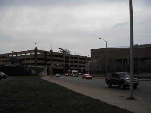
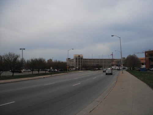
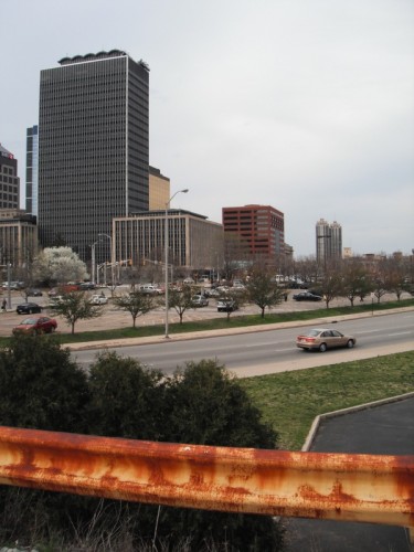
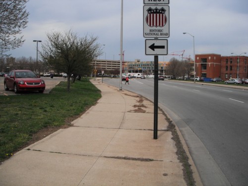
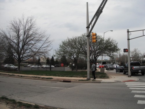
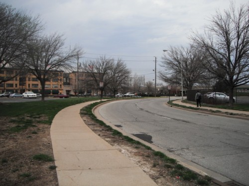
I’m standing at a point where Maryland Street has fully curved—after the intersection with Alabama Street in the photograph’s background—and the street is preparing to merge with Washington Street. Here are a few more views, pivoting from a direct westerly view toward the northwest:
And now a view to the northeast, where Maryland Street fully merges into what will be two-way Washington Street.
This is the “spur†that essentially allows Washington and Maryland Street to operate as complementary halves of an expansive, 12-lane arterial that just happens to have a full city block wedged in the middle. Standing at the intersection of Alabama and Maryland, one can see how all of Maryland’s many lanes flow in a single direction.
And here’s the view from the opposite direction:
Prior to the extensive surgery of the early 1990s, Maryland Street terminated here, at the viaduct/parking lot for the Indianapolis Heliport. Now the spur veers off to the far left of the photo, back towards Washington Street, as seen below.
Is this a problem? From a vehicular LOS perspective, absolutely not. Traffic usually flows unencumbered on both Maryland and Washington. What makes this contrived street segment frustrating is that it essentially reduces an entire downtown block to its lowest and weakest possible use: surface level parking.
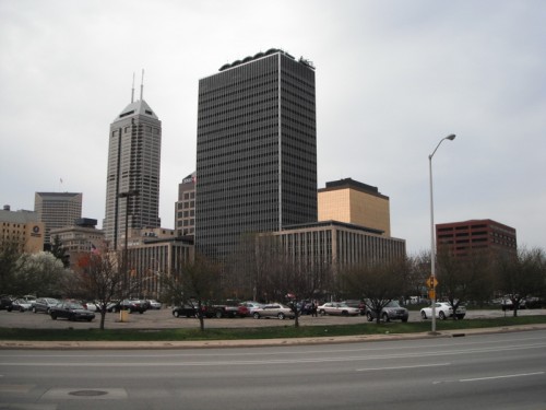
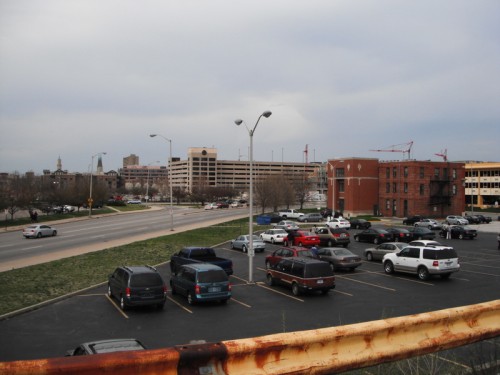
Here’s a higher-grade view of the block that would be enclosed by Alabama Street, Washington Street, New Jersey Street, and Maryland Street—if it weren’t for the spur that now runs at a 45-degree angle.
And here’s the other side of the spur, pivoting just a little bit to the east:
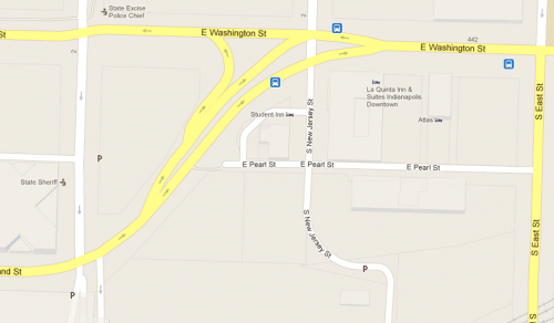
With the exception of the three-story brick structure in the distance to the right, the entire block is a parking lot. And I’m not aware of a proposal in even the distant future that will change this condition. Here’s a Google Map view of that ill-fated block:
In terms of basic geometry, the oblique angle that Maryland forms differs little from Massachusetts Avenue to the north. But Mass Ave doesn’t have those high speed “exit ramps†with turn radii that obviate the need for motorists to slow down. The engineers were even generous enough to create a hairpin ramp that allows vehicles to reverse their direction 180 degrees, from eastbound Maryland onto westbound Washington! Essentially, the design of this junction gobbles up more developable space on the block than it ever would if it were a conventional 45-degree intersection, as is plainly visible on Massachusetts or Virginia Avenues. The combination of both the unconventional parcel shapes resulting from this street as well as the desired LOS (essentially just funneling high-speed traffic to its next destination) makes this last black of Maryland undesirable both as a pedestrian and from a development standpoint. Notice that on either side of the street, it can’t support even a single curb cut.
Not even the owners of the parking lots resting on either side of this 45-degree angle want vehicles to enter or exit on this ungainly street segment. The design intends for nothing more than to convey traffic, and, barring any further civil engineering, it will probably remain this way.
In an ideal world, Maryland would stretch to the next block, hugging along the Heliport’s viaduct and elevated parking until it could terminate at New Jersey Street. Such a design would give the block a more conventional square shape and render development feasible on this giant parking lot.
The utility poles in the center of the above photo show the ideal trajectory for a Maryland Street extension that follows the conventional street grid. But this would necessitate an even greater infrastructural investment, coupled with either the removal of a part of the heliport’s viaduct or an attenuation of Maryland Street as it sidles around the viaduct to the north. Since 100-year-old maps of the city reveal that, even then, the railway viaduct prevented Maryland Street from continuing eastward to intersect with New Jersey, we’re unlikely ever to see a break from tradition. The only initiatives that would ever prompt this to happen would be if market forces demanded it—developers pushing the city to redesign the street segment so they can build to a higher or better use than the current parking lot. Developmental pressures notwithstanding, the condition of the Maryland Street spur is unlikely ever to change.
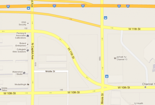
The other critical example of this one-way street stub occurs just north of downtown. Its design is much more straightforward, so it doesn’t warrant as lengthy of an explanation. Here’s a close up of the intersection:
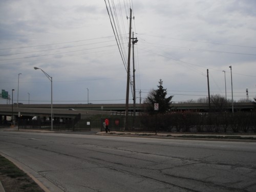
It doesn’t take much imagination to see that, in the good old days, the block used to be framed by Illinois Street to the east, 10th Street to the south, Capitol Avenue to the west, and 11th Street to the north. Once again, I remember the street adhering a much more conventional configuration when I was growing up, with 11th Street east of Capitol proceeding straight eastward, only to terminate (if I recall correctly) in a dead end where it would otherwise meet both the I-65 exit ramp and the portion of 11th Street serving that exit ramp. These days we get a sinuous curve where a two-way 10th Street east of Illinois forks to become another pair of one-ways: westbound 11th Street and curvy eastbound 10th Street. Here’s how it looks at the ground level, with my camera pointed eastward:
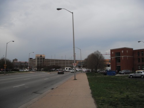
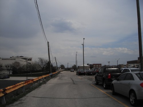
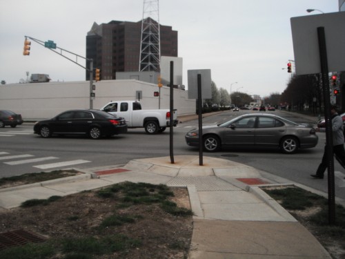
A two-way 10th Street stretches to the horizon from its intersection with Illinois Street. In the foreground, the pedestrian to the right is crossing at the one-way 10th Street. And to the left, 11th Street begins its one-way fork. Here’s how it curves to meet with the “actual†11th Street at the intersection with Capitol.
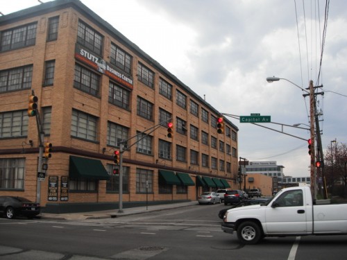
As for the block carved out by the spur, it’s nothing but a huge parking lot on either side of the street. Here’s a view at the intersection of 11th and Capitol, looking southward (directly east of the yellow Stutz Building from the previous photograph).
Interestingly, the Google Maps shows some three-dimensional shadowed structures on the eastern side of the block (fronting Capitol Avenue), but they are no longer standing. Perhaps they were demolished in the past few years, but all that is there are some scrappy vacant lots for sale.
No prospects of anything else happening on this block, at least that I’m aware of.
In many regards, the 11th Street spur is a more egregious design than the Maryland Street one. Not only does the curvy shape of the street effectively preclude any development because of the consequent unusual shape of the parcels (hard to build without resulting in a lot of wasted space), but the 11th Street one-way doesn’t even offer a significant means of reaching any destination. 11th Street only continues for four blocks, changes names to Oscar Robertson Boulevard at the intersection with Martin Luther King Street, then, after another two blocks, merges back with 10th Street in a two-way design. I suppose this pairing between 10th and 11th Street helps for traffic flow in the area around the IU Medical Center and for some of the IUPUI commuters, but the designers of the road could have achieved a similar one-way pairing with 10th and 11th without having to render an entire block unusable through the construction of the 11th Street stub. The curvy layout is less compatible with urban design than a 45-degree approach.
Indianapolis is hardly unique for containing these street segments, grafted onto the grid ex post facto during an era when the greatest priority was to channel traffic through downtowns that were persistently losing jobs to the car-friendly suburbs. In the early 1990s, when public investment in downtown revitalization still seemed like a huge gamble with a questionable payoff, these one-way spurs surely seemed like a smart decision. With the wisdom of hindsight, it now seems clear that they not only detract from the pedestrian density that endow downtowns with their inherent appeal, but they repel any further private investment, at least on the blocks that the spurs directly impact. I’m not sure I can offer any realistic short-term solutions, which goes against my principles in writing urban advocacy blogs. My only hope is that market forces will eventually force engineers and planners for the City to identify a better use of these blocks—particularly the one at Maryland Street, sitting just four blocks from the absolute center of town.

Another (simple) solution to the block east of the jail is to route “eastbound Washington” up a two-way Alabama, and make Washington two-way in the block between Alabama and New Jersey.
One might also upgrade Pearl St. east west across the current “diagonal” block, to serve the heliport parking deck and the three-story brick building. It would also link to East St. for local traffic. That would allow the two half-blocks to be used as a future southward extension of Market Square redevelopment.
There were two or three buildings across Capitol from the Stutz until the past 5 years or so. The popularity of the Stutz for office use, as well as the removal of surface parking for the Fairbanks and Lab buildings of IU Health, created some need for additional Stutz parking.
The owner of the Stutz was floating a huge condo/retail development for that block several years ago right before the market crashed. Maybe this is when those buildings were demolished?
Thanks for the comments, Chris. Just about any of the solutions you proposed would be more efficient and a smarter use of the land. The only problem is that they force drivers to make 90-degree turns, which will require them to slow down more…obviously a big no-no in the world of traffic engineering. It will be interesting to see if the City of Greenwood implements its downtown plan, which we wrote about earlier–quite disapprovingly because of the elaborate series of one-way streets the City hopes to include. (https://urbanindy.com/2012/11/27/greenwood-main-street-should-it-surrender-to-the-flow/) What Greenwood is proposing would also require hard right turns to achieve an elaborate series of one-ways. It may prove a good crucible for assessing the effectiveness of one-way spur streets at stimulating development…or assessing the lack thereof.
Eric, refresh us on timing of the Washington split. That always seemed to me “the usual” state highway solution for running a major route through downtown, and I had assumed it dated to the period when INDOT still “owned” US40 through town.
—
This gets to my second point: the “northbound Alabama” solution could have a nearly-continuous right-turn-only lane or lanes, maybe a 15-20mph design with a pedestrian respite zone at the SE corner of the intersection and a separate crossing signal. It would require some alteration to the little faux-park (the Presidential Grove or some such name), but that might not be a huge loss.
Based on MapIndy’s aerial photos, as of 1979 Washington Street still crossed White River on what is now the pedestrian bridge. By 1986 (the next available photos), the zoo and WRSP were under construction and the Washington-Maryland split was in place and the new bridge was in use. As of 1986, Maryland appears to have been one way east through downtown, but Washington remained two way. Washington was one way west only from West street until the point where Washington and Maryland reunite by WRSP. By 1991, Washington was one way all the way through downtown, and the crossover between New Jersey and Alabama was constructed some time between 1986 and 1991.
One of those rare articles that prompted me to look at my environment with a different eye. I’ve driven these areas for years and never considered the points you bring up. Thanks!
I agree. Great article!
You mean you’ve never sped out of downtown on Wash St? Lol
Agreed. I work downtown and even look at aerial photos of downtown often, and I’ve never thought about the problem that these spur streets cause.
As a regular visitor to your city, I have considered staying at the LaQuinta by that intersection. But I have not mainly because the combination of speeding traffic, narrow, deserted sidewalks, open surface parking, and the characters that congregate around the jail and bail bond shops make the me feel insecure walking the area alone in the evening.
Not really covered in this thread, but it underscores my contention that this site and Market Square are not desirable redevelopment sites as long as they are bracketed by jails at Alabama and College.
… and that’s why 257 apartment units are being built right in the middle of that area as we speak?
Note that this is being done with a considerable development subsidy. The Market Square site will likely require the same.
It also isn’t being built on the block in question. No proposed development activity along the Maryland spur that I’m aware of–plenty of better places to build.
It’s all about moving cars and these spurs being mostly on the periphery of downtown, few care that the turning radii and speeds are excessive and detrimental to pedestrians.
While they are indeed mostly on the periphery of downtown, the Maryland Street one featured heavily in this article most definitely isn’t periphery. Though it sure feels–and looks–that way from the photos. To a certain extent, development patterns since 1990 have relegated this area (just a few blocks from the Circle, and well within the Mile Square) to marginality, thanks in part to the traffic engineering standards in place for Washington/Maryland, not to mention New Jersey, Alabama, East, and College (of which strong arguments exist for making ALL four of them two-way…but that’s another blog article altogether).
I would argue that the marginalization of this area for auto traffic and pedestrian traffic had a lot more to do with the numerous railroad tracks and rail yards that covered this area from about the 1870’s through the 1990’s.
Thanks for that update, John M. Interesting (and not surprising) to hear that it occurred incrementally. I was hoping I could dig around and find an old map from the early 1980s–back before the City began butchering Kentucky Avenue and Georgia Street to make room for the Hoosier Dome. But I didn’t. Very interesting that the Maryland Street one-way preceded the Washington Street, indicating that, at least for a few years, Maryland Street didn’t have a fully one-way complement.
Based on the aerials, Kentucky Avenue was intact in 1962 (no surprise) but was gone to the extent it is today by 1978, by which time the Hyatt superblock had been constructed. It looks like the beginnings of the convention center were in place as well. Unfortunately, the 1972 aerial photo for nearly the entire southwest quadrant of downtown is missing, so it’s tougher to pinpoint.
http://maps.indy.gov/MapIndy/
The original convention center opened in 1972, so I think that’s when Kentucky got whacked at what’s now Missouri.
Maryland Street between Delaware and New Jersey is an absolutely terrible place. Everything about the design makes it unsafe and unwelcoming for pedestrians, including the curvature of the road, which begins right before the intersection with Alabama, combined with a planter/wall along the north side of Alabama which it makes it difficult for pedestrians to see traffic approaching on Alabama. For some reason, 90% of drivers stop beyond the stop line, well into if not all the way across the crosswalk. Maybe it’s because the intersection is so large and the traffic signals are so far away. Maybe it has something to do with the way the road curves just prior to the intersection.
There’s no crosswalk on the south side of the intersection in front of the parking garage entrance/exit, but many pedestrians cross there despite being forced out into the street or in between stopped cars. The pedestrian signal to cross at the west side of intersection only gives a limited amount of crossing time, far less than the amount of time that the light is green, but of course you can’t see the green light if you are crossing from south to north since Alabama is a one-way southbound. There’s no conceivable reason I can think of to provide a shorter crossing time, especially since there should be no turning traffic from Alabama to go west on Maryland.
There also should be no turn on red from eastbound Maryland to go either south on Alabama or enter the parking garage since you can’t even begin to see if there is traffic coming south on Alabama until you have driven all the way through the crosswalk.
And finally, the traffic signals for Maryland drivers at New Jersey are obstructed, especially in the summer, by the trees along the south side of the street until you are about 25 feet from the stop line. Yet another dangerous design flaw that would be avoided if there weren’t a curved approach to the intersection. I can’t understand why they wouldn’t place a signal farther north that can be seen before almost being in the intersection.
In summation, this two block stretch is quite possibly the worst designed street in the City, and that’s saying a lot.
Edit in the 1st paragraph of the previous post:…combined with a planter/wall along the north side of Maryland which it makes it difficult for pedestrians to see traffic approaching on Maryland…
Sorry to confuse things by typing Alabama, when I meant Maryland.
Thanks again for your observations, Idyllic. I definitely experienced some of the frustrations you were describing, and the conditions along this segment of Maryland are definite inimical to development or further economic growth. However, despite much competition, I’d still vote for the West/I-65 exit/Martin Luther King/10th Street to be the worst designed piece of street downtown, followed by…well, just about the entire remaining length of West Street.
I certainly won’t argue that 10th & MLK isn’t terrible. But maybe it’s not a fair comparison. Could you imagine how much worse Maryland Street would be if it also included an interstate interchange in that stretch?
Eric, West St. has always seemed to me as if it were designed to be the fourth side of a complete downtown inner loop, then aborted.
I thought I read somewhere that was originally the plan, to turn West Street into an interstate.
The owner of the Stutz was floating a huge condo/retail development for that block several years ago right before the market crashed. Maybe this is when those buildings were demolished?
I don’t know about West St, but I thought that Holt Road was originally intended to be the western leg of a complete inner freeway loop.
— Just look at any map to see the intended design. Holt Road was designed to be an “Expressway” from Weir Cook Airport over to I-74, which was to be named Airport expressway. The ramps were built at the I-74 interchange, plus Southeastern and Holt Road were upgraded to “freeway grade”. The future generations dropped the ball and never did their part by completing the project …. but it’s never to late. Xoxo.
I’m not sure what you’re talking about. Holt Road doesn’t go to the airport and it runs north-south. Holt did get upgraded to just north of 10th Street, with a two-lane zigzag to 16th Street that has never been redone (which is certainly irritating).
Are you talking about Raymond Street? The Sam Jones (formerly Airport) Expressway was built to create a freeway connection from I-70 to the airport replacing a zigzag route using, as I recall, Raymond, Kelly, and Bradbury streets. (Raymond Street didn’t extend to the airport in those days.) There was a long-standing plan to widen Raymond Street from east of the Airport Expressway to Southeastern Avenue into a 4- and 6-lane divided road, a project that didn’t get done until about twenty years ago. As far as Southeastern being a freeway, I have never seen any plans for that (and I’ve lived here for 65 years). Southeastern between I-74 and Raymond Street was 2-lane until about twenty years ago.
As far as the ramps at the I-74 interchange, those were needed regardless whether the roads were freeways, expressways, or regular streets.
Thanks again, one and all, for the extensive comments and second (third, fourth, fifth) visits to this article. Glad I was able to stimulate conversation on a topic that I think merits much more consideration than it receives.
Based on the treatment the streetscape currently endures, my suspicion is that West (or West/Missouri) was originally intended to serve as the western side of the downtown loop. Granted, it would have severed downtown’s link to Military Park and IUPUI, but during the peak time of urban freeway construction, most designers generally saw that as a minor sacrifice.
Actually Eric I believe the roots of the transformation of West/Missouri streets into an interstate access road was part of an “urban redevelopment” project under Hudnut in the mid 1960s. This is when the wholesale demolition of the residences and commercial spaces that lined West St began. I can’t tell you the exact years, but West St has been widen at least twice from 10th St to Indiana Avenue. I’m not sure exactly when IUPUI had started buying up properties but I know by the early 1970s the school had started their spree,
Hudnut wasn’t Mayor until the 1980s.
Sorry I meant Lugar.
When the inner loop was being planned in the 1960’s, I seem to remember there being some talk of having a leg on the west side of downtown, but I don’t know if it would have been along West Street or on the other side of White River. I don’t recall it getting much beyond the talking stage. Instead, it was decided that West Street would serve as a collector for access to the west side of downtown from the interstates.
Of course, the idea of an interstate highway on that side of downtown wasn’t as outlandish as it seems today. At that time the Mile Square was all there was to downtown. Military Park was a seedy neglected plot of land. The canal was a scum-filled foul-smelling stagnant pool of water. Various old industrial buildings, some occupied and some not, lined the river. Only the northern of the two State Office Buildings existed. The IU Schools of Medicine and Dentistry were the only occupants of what would become the IUPUI campus. Downtown had activity only during the business day, and there was very little reason for anyone to cross West Street.
— Freeways are awesome, but they don’t work well everywhere. They are great to quickly access end points, but once at that point divided curbed roads work better. The west side of downtown is already boxed in by the river, so for that reason a freeway along West Street wasn’t necessary, but when doing planning, then ALL options must be put forth. Even the bad ideas …. Our forefathers were planning for 50 years from the time of construction, and they had seen Chicago and Dallas grow. so they knew what was coming. There is an awesome “Master Plan” they put together, and the foundations of the plan were constructed, but future generations, dropped the ball and didn’t do their part, so businesses started re-locating out to the I-465 Bypass. The failure to implement the Master Plan has caused Indianapolis to empty out and become an empty shell. INDOT warned of this in 1968, but Indianapolis just laughed at them …. Sadly, INDOT had seen other big cities fail, so knew the future, but Indianapolis wouldn’t listen. Xoxo.
Thanks for your comments, Mark. Always interesting to hear a perspective from someone who has memories from way back when. It helps illuminate why civic leaders might have made what seemed like wise decisions at the time.
Google has decided that its users of their well-liked Google Maps service will begin becoming charged a fee for utilizing their service. Websites that are going embedding a Google Map of their location will be charged a fee for usage.This new Google Maps fee is going to hit mostly the bigger companies, particularly the Travel industry. I suspect that certain websites that are the heaviest users would be websites like TripAdvisor and Expedia.`*
Head to our new blog site too
http://healthmedicinelab.com
Basically needed to point out Now i am thankful that i came
onto your website!
When did Illinois St become one way north?
Looks like it was prior to 1972, but I have no clue the exact date.
http://imgur.com/Ala8mM7
Illinois has bee one-way north since as long as I’ve been able to remember that sort of thing, which translates to the late 1980s. I’m sure it turned one-way many years prior, if not decades.
It’s one way NB in the MapIndy 1962 aerial north of South. 1956 aerial is not conclusive but it also appears that a semi is heading north in the left lane. 1941 resolution is too low, and in 1937 the Illinois corridor is missing.
I know its probably not feasible, but I have thought how interesting it would be if Maryland St. was rerouted, almost to the shape of the block that encompasses Alabama, Washington, and New Jersey. To describe further, it would and remove everything inside the block for building purposes and then run into New Jersey but still have a slight radii almost wider than the NJ radius entry to the helipad. Hope I didn’t confuse! 🙂
I know exactly what you’re saying here, Cody, and I agree completely.
— I am born and raised in Indianapolis …. Indianapolis is the baby, so it was born after most the other big cities, so we got to learn from those mistakes. There is an awesome “Master Plan” for our city, that was put together by some of the best of the best. Unfortunately, around the time Indianapolis was born, then the silly Media waged a war against Interstates and brainwashed the people into thinking expressways were more negative than positive. Indianapolis bought into the brainwashing and fought a war against freeways that lasted decades. INDOT finally got fed up with Indianapolis and washed their hands of the backwards thinking people, who thought the automobile was just a passing fad and would soon go away. INDOT withdrew funds from everything on the inside of I-465 and said you people with suffer forward in your own misguided doings. True story. Sad story. The entire north side of Indianapolis has no easy quick way to access downtown. Binford Boulevard was the northside expressway to downtown, but was never allowed to be completed. Same goes for Keystone, Meridian, and Michigan Road, which were to be divided curbed highways downtown, but never got completed. If you live in Greater Indianapolis, then avoid the entire north side of the city from I- 70 clear over to I-65. Northside got cheated out of their downtown access. Xoxo. Year 2017.