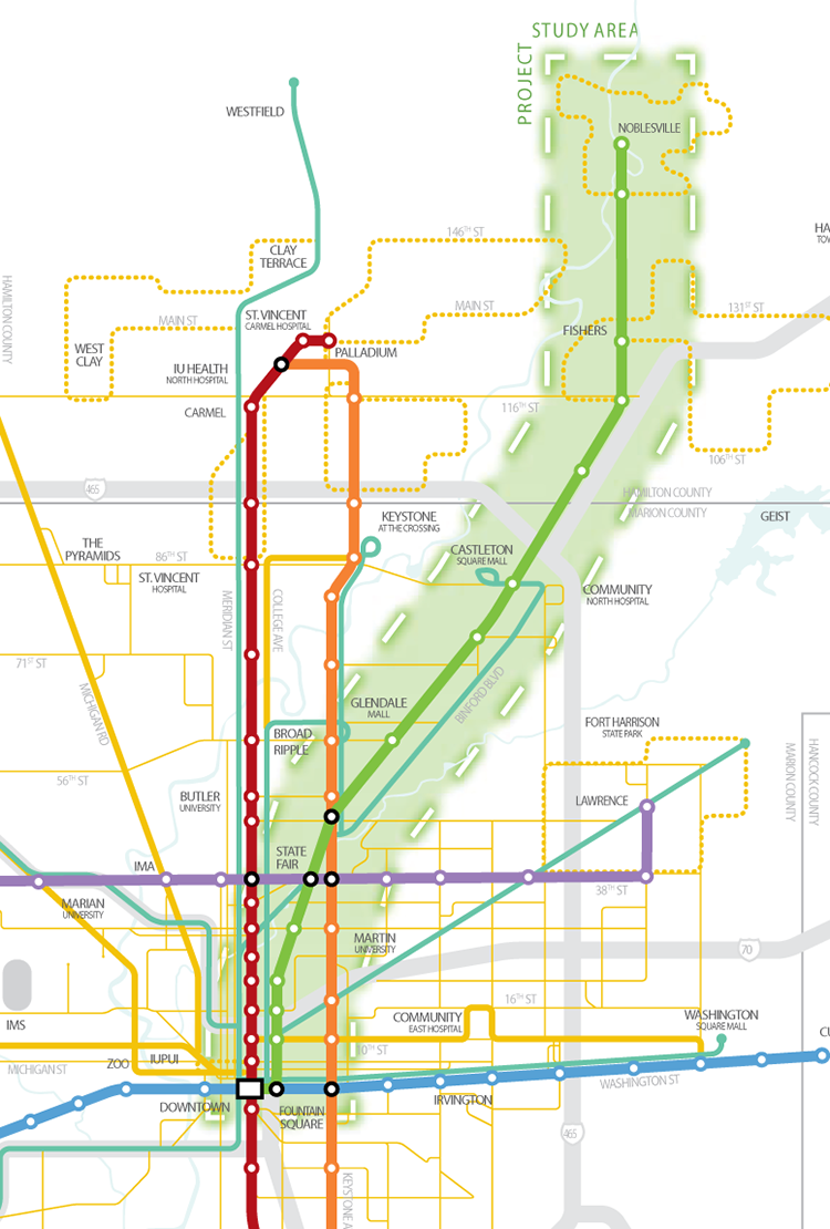
It has been quite some time since I, or anybody else here at Urban Indy, has written about the NE Corridor or as it is referred to now by Indy Connect, The Green Line. As of this writing, the Environmental Impact Statement (EIS) is being constructed by HNTB, under contract through the MPO.
With the progress of HB1011 at the Indiana Statehouse, mass transit is beginning to get a lot of attention in Central Indiana. The Green Line is the rapid transit project furthest down the rabbit hole of the three currently under study; it is also the most controversial. Originally announced, the line would be a 23 mile long rail line from Noblesville to Downtown Indy using some form of light rail vehicle. Urbanists, and many readers of this blog, question why this is the first line being studied for implementation. Suburbanites question whether this line will be rail or Bus Rapid Transit (BRT). Politicians question whether this line should even be included in the long range plan due to it’s higher capital outlay compared to the other potential rapid transit lines in the system.
Additionally, with the announcement of the IndyGo Downtown Transit Center, to be located across the street from the City County Building, people have begun to question whether the line should terminate at Union Station, as originally scoped, or whether it should divert to the future location of the transit center at Washington & Delaware Street.
Value Proposition
Why do we need the Green Line? Is it a political ploy to get Hamilton County on board with a regional transit authority? Is it to solve congestion in the NE corridor of the region? The line will arguably be hard pressed to provide congestion relief to I-69 and Binford Boulevard. With a daily trip count well over 100k in the I-69 corridor, the level of frequency needed to relieve that would be intense, and thus costly. With the future line scoped to have 15 minute headways, congestion relief seems like a tall mountain to tackle. However, for those wishing to take advantage of the service, a great deal of value could be provided. If this line were to be rail, and based on an analysis that includes a limit of 9 to 11 total stations along the route, a comparative travel time can be achieved for someone travelling from Noblesville to downtown Indianapolis. This could significantly reduce the amount of gasoline consumed by automobile on a comparative trip. Due to the lack of a direct freeway link between I-69 and downtown Indy, the Green Line could serve as a competitive alternative to travelling by car.
Second, there are numerous neighborhood redevelopment opportunities along this line. It could be generalized that fixed guide-way transit usually induces neighborhood redevelopment around station areas. Whether its rail transit or BRT, the fixed guideway should raise the propensity to draw investment. This bodes well for areas south of 52nd street where study is already underway to take advantage of future rapid transit service. The Martindale-Brightwood neighborhood has already established a plan based on a station one day being located in the heart of their neighborhood. Additionally, King-Park, in cooperation with LISC, has kicked off an 18 month quality of life study from 52nd street southward identifying opportunities for neighborhoods along the line to take advantage of the future service.
Mode

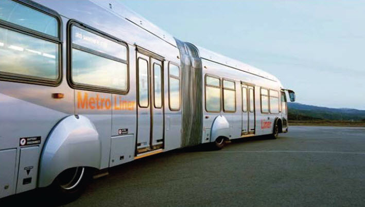
Will this service be rail or Bus Rapid Transit (BRT)? Does it matter? When examining the cost of the rail line, approximately $600-$700 million for the full 23 mile build out, it could be said that BRT could be done cheaper; perhaps $100 to $200 million cheaper. Take into account the lack of a costly maintenance facility, as well as buses being cheaper than trains, and a more frequent service is also likely achievable.
I think the bigger question with regard to mode is, how would buses be received along this line? People in general consider trains to be a premium transit offering due in part to it’s smooth ride, progressive image and general success in attracting riders. Over the past couple of years, numerous comments have surfaced on this site advocating that instead of rail along the Green Line, that BRT be implemented and the current Red & Blue lines instead, be switched to rail transit. Indeed, if one examines where current IndyGo ridership is highest, it is along Washington Street, where the Blue Line is currently under study.
The only domestic comparison to BRT along the NE Corridor, is the Orange Line in Los Angeles. With a daily ridership level north of 22,000 boardings, this line serves a similar market to Indianapolis; the San Fernando Valley of North Los Angeles. Itself a community of over a million people, and comprised mainly of single family dwellings and small to mid-rise apartment complexes, the Valley is a comparative market to Indianapolis. There, the Orange Line serves a critical rapid transit need in moving residents to a connection with the Metro rail lines which branch out in the greater Los Angeles basin. The Orange Line provides value in it’s frequent service, dedicated right of way and premium built form with state of the art stations, off-board fare collection and differentiated, articulated vehicles. To be sure, if 22,000 boardings per day could be realized on the Green Line in Indy, it would be considered an overwhelming success story for a conservative Midwest market. For the success that a similar automobile oriented market has achieved elsewhere, a valid case can be made based on ridership success, for BRT along this corridor.

Something which hasn’t received a lot of focus, is how the line will terminate downtown. The original scope of the project spelled out that the line would use Union Station downtown as the terminating station. The only other downtown station would likely be 10th street and it can be argued that this would be perceived as a value trade off due to it’s remote location and need for a transfer to reach the downtown job centers. Certainly though, there are efficiencies that can be realized by diverting the original line at 10th street, dedicating lanes solely to the vehicle, whether it be train or bus, and routing it through the downtown area closer to the job centers; the original scope would have a train travelling on CSX tracks south of 10th street. As you can see to the left, and using data provided by the Longitudinal Employer Household Dynamic website, a downtown routing would better serve jobs and create more value for potential commuters; if roadway can be secured to solely and rapidly route trains or buses through the downtown footprint.
JobsÂ

Take one look at jobs in Central Indiana, and it doesn’t take long to observe the decentralized geography of their clustering. The primary concentration of jobs is in the core of downtown Indianapolis. Outside of that though, it becomes difficult to lobby for another pocket being the most dense and that it should become the focus of intense rapid transit. Data often cites the US31 corridor in Carmel as the second most dense concentration and certainly that is true, but one visit and it becomes obvious that the current built form makes transit service difficult to provide. Large surface parking lots surround all the office buildings in this corridor so at best, one can only get 1/8 to 1/4 mile from the front door of these massive office buildings. That alone creates a planning conundrum in determining how rapid transit can serve this market in a way that makes it desirable over private use automobiles.  Making a case for the Green Line then, one can surely point out the large number of automobile trips as a primary market that could be served by Green Line service. This would also peg most of those outlying stations as likely park and ride locations with the same impediments to urbanization around them as described with the US31 office buildings. However, the urban core terminating locations could efficiently shuttle workers to jobs.
Conclusions
Should planners be emphasizing this line over others in the Indy Connect plan? Urban Indy will not solve that question, but we instead hope to shape how people perceive the value of this line moving forward. Certainly there will be valid arguments from all sides. Should we boost our city’s image by building a rail line and joining the class of cities that have chosen a progressive mode of transportation? Should we instead focus on a world class BRT system that would rival the Orange Line (Los Angeles) or some other dedicated guideway systems? Should we even be constructing a rapid transit line on this corridor at all? Stay tuned as 2013 promises to flesh out many of these questions for residents to decide the answers to. For more info on the Indy Connect plan, visit www.indyconnect.org
I would like to see the Green line as a rail line instead of BRT.
We have one chance to do “world class” BRT in metro Indy, The Green Line. Every other proposed BRT line would be second class, simply because of the dedicated ROW issues and car-BRT conflicts.
We should do BRT on The Green Line. It can always be converted to rail if it achieves stellar ridership levels.
My concern is that we are pushing this as a necessary service for many people and a great option for others (both true). Why are we going to put the largest single investment on a route that is used heavily by people who have many other means to travel? If transit is a benefit to the NE, then folks will have no issue with riding a first class BRT system. If the complaint is that it isn’t a train, then the project failed to address the true efficiencies of transit.
Thus my problem with HB 1011 and the way the agenda is framed.
People who are too poor to own cars, or too old, or handicapped – they need and deserve help public from the public.
People in Fishers are not such people. If they’re mad about their commute downtown, they should live downtown rather than 20 miles away.
Maybe I’m a little naive or uneducated about the actual geography of this green line, but I don’t see the incredible redevelopment opportunities along it. I understand the idea that more residential and/or mixed-use will fill and replace some of the old industrial land in the King Park & Martindale-Brightwood area, but I don’t foresee a lot of development of vibrant, high-density, mixed-use TOD-type nodes, whether it’s BRT or rail, in part because the line in many cases is so far removed from a parallel arterial street and it is running through fully developed, single-family neighborhoods, where the cost and difficulty of parcel assembly would be prohibitively difficult. I’m open to being convinced otherwise, but I just see this line as a commuter rail (or BRT) line that won’t have much impact on the areas adjacent to it. I’d much rather see all the other lines prioritized over the green.
I think you’re discounting the possibility of TOD on the green line. I wouldn’t argue that every possible station location is TOD gold, but there’s significant potential around stations in downtown Noblesville, 71st, Keystone, and any of the many possible locations south of 38th. Between Noblesville and 71st, I assume they’d be looking at park and ride (with the possible exception of 116th).
My issue with this is the class of people it serves. Along the Washington corridor, a line would serve people who generally have no other transportation (or at the very least, struggle to maintain a car).
The Green Line will be serving the middle and upper-middle class who do not currently support Marion county with their property taxes. They come downtown for work and leave at the end of the day.
About the only benefit of this is that at least they won’t be depositing their pollution as the enter and leave downtown.
You do realize there is a significant amount of Marion county residents along this line right? There is a large portion from 38th to 52nd that would be served as well as the people who live south of Fall Creek.
I see your point but just want to point out that there are a lot of people with Indianapolis mailing addresses who will benefit from this too. I live in one of these neighborhoods and I can tell you with confidence that there are plenty of people with limited transportation options. More than Washington St? Probably not, but still measurable.
I have zero problem with a line running up to 52nd. Heck, I’d be happy to have it go to Castleton Square Mall.
I would like to keep this Indianapolis focused and try to avoid incentives for people to move further out in Hamilton Co.
However, that being said, I could be persuaded otherwise depending on how the funding/benefits work out. If 50% of the funding is going to be spent on the Hamilton Co portion, but only 25% of the funding comes from there, then I’m fully against it. If Hamilton Co wants to fully chip in their full share of the cost in their county, I’m likely to be more in than I am now.
Being a downtown resident, I want to encourage people to embrace what has become one of the best downtowns in the midwest. I don’t want people to just swing through and then be on their way to car-centric suburbia.
Couple things –
Until very recently, no stops were planned for the Green line, south of 38th St. Meaning, the train wouldn’t stop in black neighborhoods.
The Green line assessment info has been scrubbed from the transit website. It’s available thru archive.org, but is incomplete at best.
The bulk of capital spending under the long range transit plan is for rail transport, including a line to Zionsville – the whitest, most affluent part of Indiana.
I can assure you that there have been planned stops south of 38th street for quite some time. I have been involved with the NE Corridor Citizens Advisory Committee for a couple years now, and there have ALWAYS been stops planned. One near 25th street area and another perhaps at 16th or 10th.
As for the Zionsville line, I too find this conflicting, and have yet to see anything more on it except a line on a map.
In my opinion, do commuter rail on the green line, i.e. metra. Pretty cheap, will be popular among Hamilton County Suburbanites. Do light rail on red and blue lines running on/under city streets until 71st St(North Red Line),Fountain Square(South Red Line),The Zoo(West Blue Line) and completely on-street for the East portion of the Blue line. Also Indianapolis should not have all lines go down one street, but run in 1 direction on all different streets to get the most coverage possible. Additionally, major downtown companies like Eli Lilly and Simon should contribute to the plan to get their workers downtown easier and possibly other businesses located along the lines too. If this is done, our light rail could be one of the best systems in the country, possibly even with underground stations downtown. Check out this map that I made a while back showing some ideas I have of future Indianapolis rail transit. http://g3.imapbuilder.net/_map/?s=1905f6e1d418ebf0da57712a9975adaf&m=20478
I think this needs some deeper thought. What is the current market like for housing along the corridor? It’s not likely to be strong enough to create the transit focused communities you’re looking for. The land values need to be higher in order to get the densities needed. Additionally, this line, if planned as BRT is just building another dedicated freeway that at some point someone is going to want to open up for cars.
I think commuter rail lines should be reserved for after you’ve developed a robust transit system in the core. Build the BRT lines in the core correctly, and the rail line will then have a distribution system. If built by itself, you’ll get a line that might kill political will for transit extensions for years to come.
Curt, obviously you’re dead right in saying Indy lacks any other major commercial nodes aside from downtown. To call North U.S. 31 the second highest is a discredit to downtown, because it isn’t a node or remotely concentrated. It’s just a corridor of corporate centers whose property lines generally bound one another.
If anything, the Keystone at the Crossing/Fashion Mall hub is the second largest node (and Indy’s closest equivalent to a real Edge City, though small by many other cities’ equivalents). It seems to win some lip service in the transit consideration, but not what it deserves: no real convergence of bus lines that I can see. This is particularly disappointing, considering that development and redevelopment routinely takes place at this completely auto-oriented intersection of limited access exit ramps.
For similar reasons, I have long advocated a zig-zag “central corridor” from the west side of downtown north on Capitol/Illinois (catches most downtown offices, IU Health/Methodist, Ivy Tech, Children’s Museum), then north on College from 34th or 38th, then east on Broad Ripple to Glendale and north on Keystone to the Crossing area, thence to Downtown Carmel.
Its south leg would travel across South and East (Stadium, Lilly, and Rolls) or Virginia to Fountain Square.
This would tie together lots of work/life origins and destinations.
It’s effectively a blended Red/Orange line.
What we ought to be doing, at a Regional level, is to continue to explore the possibilities, and it’s the last part of that sentence that has real significance. If the only discussion takes place at the Statehouse, it will go one forever, since the perceived value diminishes as you move further away from the region.
It is my opinion that Indy goes the cheap route too often. The lack of investment generally leaves people feeling underwhelmed. If we go the bus route, I believe ridership numbers will be disappointing. The plug will get pulled on the project, and area leaders will act as if we gave it a try and it just didn’t work. Such a failed effort would set Indianapolis back decades. It is time we stop being cheap and start doing things right.
I have used the IndyGo service many times and there is nothing enjoyable about using the service. The seating is uncomfortable. The ride is noisy and bumpy. There is also the issue of having a lack of real bus stops. A sign on a post is not a legitimate bus stop. There must be protection from the elements. Let us not forget that there is also a stigma when it comes to riding buses.
I have used a number of different rail products over in Europe. They are all far superior to bus service. The light diesel units are ok. They are quieter and cleaner than the traditional diesel trains in the United States. But they are not the best way to go. Electrified rail is ideal. Aside from the opportunity to use green technology, electrified rail is quieter, the trains lighter, and the stopping distances shorter. Electrified rail routes would give people a quiet, smooth, and comfortable ride and make conducting work while commuting much easier.