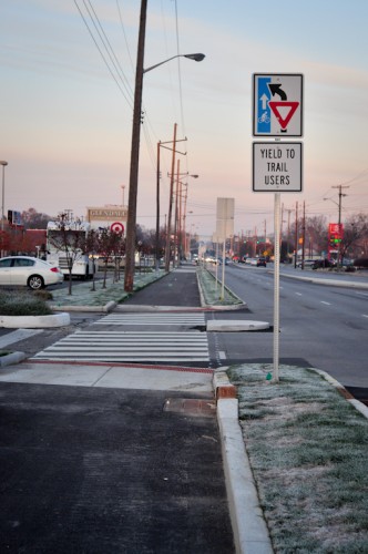
November is upon us! The temperatures are dropping and the leaves are falling. The construction season too, will be drawing to a close soon. Â As we look back at the construction projects that have transpired this season, Urban Indy has kept a focus on the 62nd street trail on Indy’s northside which begins at Allisonville Road and terminates at Keystone Ave.
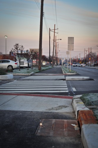
As of this column, the trail for most practical purposes, is complete. Final pavement layers have been laid, signage is going up and street crossings are being striped. A recent observation of the trail shows that there are merely small punch list items remaining such as landscaping and sod work, dirt pile removal, etc.

We have seen some loud objection to the trail here at Urban Indy. Most notably, there were some resident concerns about the construction mess, the design itself and the timing. However, in this writer’s opinion, all of those concerns are water under the bridge as the trail weaves beautifully through the residential neighborhood opening up a new pedestrian and bicycle path along a corridor which previously had no options.
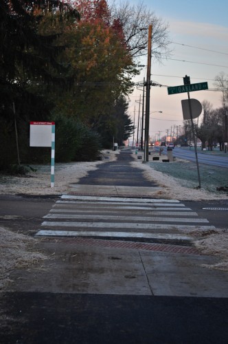
Additionally, riders of the IndyGo 19 now have a clean and paved spot to wait on buses effectively expanding the catchment area for IndyGo. The connectivity of this project cannot be underscored. Although anecdotal, I have observed people throughout stages of construction using the trail, even with the presence of dirt, mud, or unfinished ADA crossing.
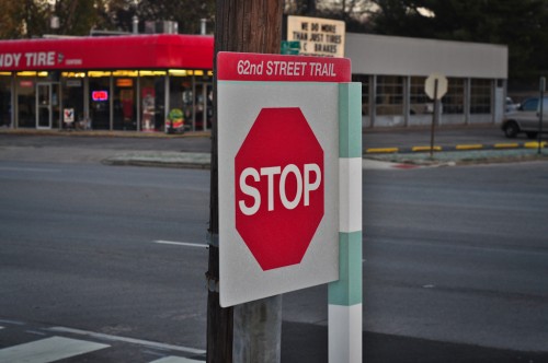
I firmly believe the signage found along the new trail to be one something of a surprise. Watching the construction of the trail, I did not think about the signage that might provided. In traditional Indy style, there are square signs on wooden posts indicating the name of the trail along with stop signs, etc. Additionally, there is a lot of signage warning motorists that there is a cycling and pedestrian trail here. The only thing that I would find lacking, is any sort of way-finding. There is no direction to cyclists that “Broad Ripple is this way” or “This way to the Monon Trail”.

Locals of course will not have a significant issue, and it could be argued that this trail is so far from the urban core, it may not receive a significant amount of out of town visitor traffic. However, that would be my only criticism.
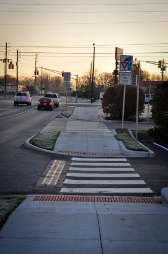
Although the pictures with this column show a trail that is still fresh off of the truck, it should age gracefully. The landscape along the route lends itself to growing in around what has been built. Additionally, the hard-scape lends itself to a long term future that will provide a safe and easy to travel corridor for users. I fully expect an increase in active transportation along this corridor not only by current residents, but also to a wider audience of travelers who desire an option to the automobile whether that be for recreation or commuting.
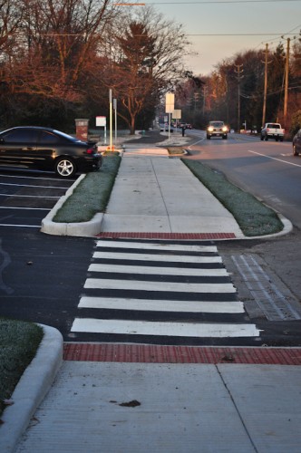
Adding pedestrian and bike infrastructure is a good thing, but we shouldn’t pass up the opportunity to improve these projects by pointing out their shortcomings. I haven’t followed this project very closely, but here are three quick questions:
1) Did the trail get completed without a curb separating it from the the street in front of Tyler Automotive? If so, why is this acceptable? Why wasn’t the nearer to the intersection of Tyler’s two driveways onto 62nd Street closed to improve safety and reduce potential vehicle pedestrian conflicts so close to an intersection?
2) Why did the City unnecessarily install a driveway across the trail from 62nd Street to the undeveloped potential outlot at the SW corner of 62nd & Rural when any future development at this lot could be adequately served by internal access from the Glendale property? The undeveloped land is under the same ownership as Glendale, and the Glendale parking lot is already designed with two internal access points laid out to access this potential outlot.
3) Why did the City feel the need to maintain two vehicle travel lanes in each direction on 62nd between Keystone & Rural, when only one is present to both the east and west? Are traffic counts on this short segment greater than to both the east and west? A slight reduction in the roadway width would’ve allowed a wide enough green strip between the trail and the roadway to provide for tree plantings and other landscaping and amenities. Shade trees and other amenities could’ve made this portion of the trail an attractive and inviting place to be rather than just a utilitarian bare essential.
We (Rundell Ernstberger Associates) were the lead designers of this project and worked closely with the City for more than a year on the design; I am glad to see the discussion of the project here and welcome all comments and critique. A few responses to the questions submitted by Idyllic:
1) The original plans did remove the drive cut mentioned for Tyler’s, along with the northern cut along Rural Street; this business has a total of 4 drive cuts along 62nd and Rural and we and the City felt the two closest to the intersection could be removed with little impact to their operations and to reduce conflicts at this intersection. The owners protested and the design was changed in the field to what was installed. The City is typically very reluctant to remove drive cuts without owner approval, even if the removal is clearly the better design solution. Our firm also designed the Cultural Trail and drive cuts were a significant challenge on that project as well; if removal is not possible, the next best solution is to make sure the cuts are clearly marked and signed to reduce potential conflicts.
2) The “driveway” you mentioned at SW corner of Rural and 62nd Street is not a driveway; it is an accessible bus stop.
3) Between Keystone and Rural, the City did agree to remove a third lane of traffic and narrow the center median to create space for the trail; without this decision, there would be no trail along 62nd Street. The removal of an additional lane would simply not be functional given the traffic on this section and the need to accommodate transit stops, though I do agree some trees here would be an improvement. Like Mick Jagger says, “No, you can’t always get what you want. But if you try sometime, you just might find, you get what you need.”
Obviously there is always room for improvement in any project but, on balance, we think the trail provides a safe transportation alternative between Keystone and Allisonville where none existed before.
There is not a curb in front of Tyler’s. It’s really tough to come up with a design that benefits everybody. It was the last portion of the trail to be completed and I wondered what it was going to look like. I did not get a photo, but there is a wide striped pedestrian style pattern from the south side of Rural all the way to the other side of Tyler’s. It is so obvious and odd looking that for a motorist to miss it would be indefensible. It is not the optimum design from an active transportation advocate’s point of view, but it works and does provide a clearly marked lane for cyclists and pedestrians.
.
The rest of the items I cannot speak on. This trail was 100% federally funded so it has been in the planning/design stage for years. Its possible that the design predates what happened with the redesign of the Glendale mall. I cannot say that for fact, but just a thought. But you see this pattern all over the place. Not with just trails, but also with road projects. Notably, in the suburbs where greenfield development is taking place and you see driveway stubs end into a cornfield. Perhaps its the same sort of situation here. Property plans do include driveway locations. perhaps there was one here before.
.
I too would like to see more trees or landscaping along Glendale, but the trail itself is pretty nice and I expect that it will be a good riding/walking experience despite the landscaping being absent. Im certainly not going to tear the project down based on the items you mentioned.
.The trail accomplishes what it was designed to do.
Curt, I’m not sure what you mean by “I’m certainly not going to tear the project down based on the items you mentioned.” Does that mean that you wouldn’t highlight them as inadequate because you would be concerned that a constructive criticism would be interpreted as a lack of appreciation for a project creating something better than what existed before? We can’t expect the City to provide better designed projects if we don’t highlight the shortcomings of what they’ve done. Sure, we can all agree that this is better than the alternative of nothing, but why the hesitancy to provide constructive criticism? Of course, one can say that the trail accomplishes what it was designed to do, but why not design it to accomplish more in a better way?
I’m not trying to defend the design. Trust me, I would have done things differently and as you put it.
.
it’s hard to say that this trail is a failure though. It provides a smooth, easy to navigate and dedicated right of way. It creates a sense of place despite the short comings that you and I are talking about. I get the sense that people will still feel that they have arrived at something special when they turn from Allisonville onto this trail or cross keystone from the west side and jump onto this thing.
.
It would have been nice to see more shelters. Some more trees. Further elimination of roadway, etc.
.
I’m not disagreeing with you but I am also not going to spend this space tearing the thing down because of a few under-par design flaws.
Curt,
I’m glad we appear to be pretty much on the same page regarding design flaws. I guess we just have a little bit of a difference of opinion on the priorities of journalism. I would use this space to constructively point out the components of this project which fail to produce world-class results, which doesn’t necessarily equate to calling the whole project a failure, in the hope that it would result in an even better design for the next similar project. I appreciate the effort you put into this website and enjoy the opportunity to read and comment thereupon, but I don’t think we can realistically expect the City to provide a better design next time, if the reviews that are published don’t shed some light on the importance of the project’s shortcomings.
idyllic, extra traffic lanes are a little more defensible (for safety reasons mostly) in places where there is a high volume of turn-in and turn-out movements on an important through arterial. (And, since I’m the guy who hollered loudly about removing capacity from 62nd west of Keystone, I’m at least consistent.)
A trail like this running up College from the blind school all the way to 96th St. would be awesome. It would connect several neighborhoods and provide a safe place for people to catch the 18. Correct me if I’m wrong, but if this were done people would be able to walk on a sidewalk or trail all the way from downtown Indy to the Monon Center in Carmel. Something needs to be done to complete the connection.
People can already walk/bike on a sidewalk or trail from Downtown Indy to the Monon Center in Carmel (and beyond).
.
The Downtown Cultural Trail connects to the south end of the Monon at 10th Street. From there, the Monon runs through the King Park, Mapleton Fall Creek, Meridian Kessler, Broad Ripple, Shore Acres, and Nora neighborhoods before passing into Carmel and then Westfield.
Chris, Thanks for your comments, but you’re missing my point. This is the only section along College that doesn’t have a sidewalk. People have to walk on the street to get to a sidewalk and stand in a ditch to catch the bus.
That’s different from through-trail connectivity, which seemed to be your main point.
.
Lack of sidewalks is an issue along most arterial spokes outside the old city limits: Michigan Rd, Meridian, College, Allisonville, Binford, Fall Creek Rd., Mass Ave, Washington, Shadeland, Brookvlle, Southeastern, Emerson…. that’s just half of the County, and it’s an incomplete list off the top of my head. I agree: it will be a big issue if/when the IndyConnect initiative results in increased bus service along those roads.