On November 3rd, 2011, the Indianapolis MPO published a document (click to open .pdf) titled, “Bus Rapid Transit (BRT) – Corridor Elements Workshop”. The document is an in-depth examination of the study about to commence on the East-West corridor (Washington Street) and the North-South corridor (Meridian/College/Madison).
As Urban Indy reported back in October, Indianapolis received a $2 million grant to begin study of both of these corridors. This document is the first step towards defining the study area, possible alignments, vehicles, stations and other required infrastructure. The document also covers operating parameters, overheads and the financial requirements of the service. To be clear, this document is a guide only. It will guide the study which is part of the requirements for obtaining federal funding for such a project. It should be note that no decisions have been made and these are simply educated selections that make sense for the potential project.
However, from a transit geek’s perspective, this is the first step to answering a lot of the questions we have asked at this site. What will the service look like? Where will stops be located? Will there be dedicated lanes? This document attempts to outline some of these questions that will be answered in the coming Alternatives Analysis (AA). The AA will define the best answers to these questions and those will be answered, ultimately, by the Indianapolis Regional Transportation Council with a lot of input from citizens and other elected officials.
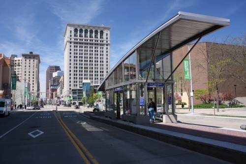
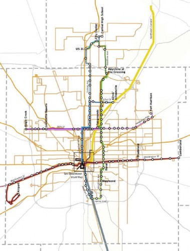
Some of the coolest parts of the document are the possible stations which create many talking points. As you can see from the maps, station locations have been proposed at periodic points along the routes. Most are located near existing job/activity centers. While thestudy covers all of the BRT routes called for in the Indy Connect plan, the grant money is solely for studying N/S & E/W routes. It is those corridors that I wish to focus on with the remainder of this post.
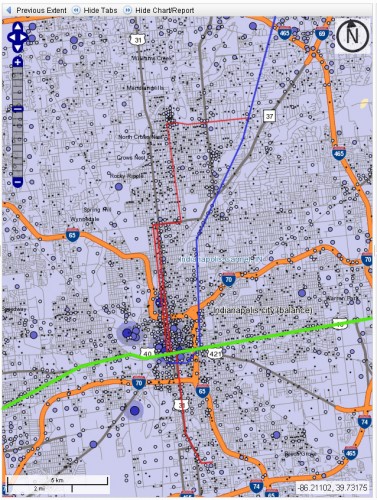
First and foremost, I am pleased to see that the study examines a N/S alignment that travels from downtown to Broad Ripple. The proposed route closely resembles one that I have pointed out in the past in my lobbying for light rail (see map above for proposed LRT route vs job centers). The line would serve dense job, population and activity centers and create a valid rapid-transit alternative to the automobile. The southern portion of the line would travel along Madison Ave to the University of Indianapolis. Unfortunately, it would miss the heart of Fountain Square.

The E/W alignment, along Washington Street, would also serve what is today’s most frequented Indy Go bus line, the #8. It would provide service through the heart of the city and provide frequent service to Irvington, downtown and the airport. These are all key job and activity centers.
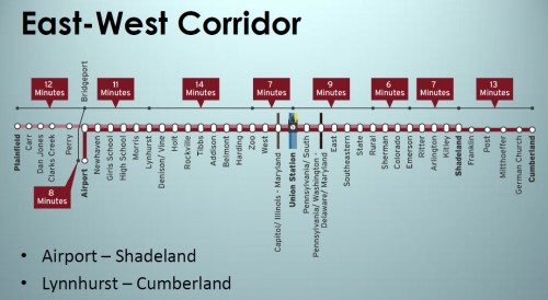
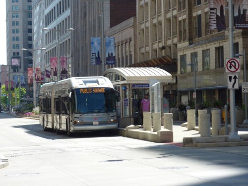
Design of these routes is also considered in this document. Federally funded programs stipulate that a significant portion of each route must contain “bus only” lanes. This answers some of our previously asked questions about dedicated lanes. However, the study points out the difficulty of this in some areas of the proposed routes. Managing frequent service in these areas will likely be a key metric of success once service is in place. Federal programs also stipulate that the buses must be branded differently than normal buses which for transit riders, will represent a new look most likely in the form of articulated buses with special paint.
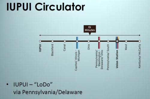
Downtown circulators are also covered and would come online at the same time as phase 1 of the N/S & E/W routes. These routes are laid out as indicated on the map above and indeed, they would provide significant benefit for people who live, work or attend school downtown. These BRT circulators would serve IUPUI, Lilly and interface with the proposed NE Corridor commuter rail line which is also currently working it’s way through the EIS process. However, if federally funded, how would dedicated bus lanes in the tight confines of downtown work out? The document does not elaborate on those routes.
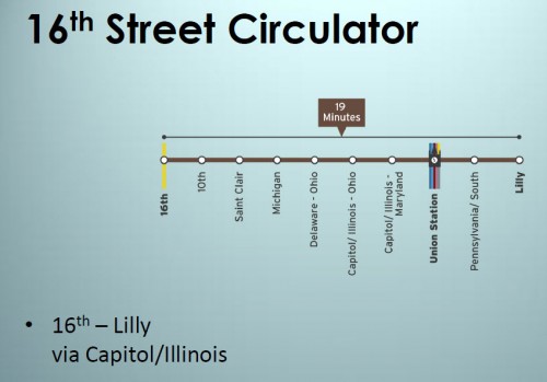
These questions, and many more, remain to be answered by the Alternatives Analysis that is set to begin study this year. Upon completion of the analysis, we will have a much more firm timeline on implementation and exactly how each service will operate, where it will operate and what the vehicles will look like. A couple final notes to remember. The timeline in the report does not take into consideration that a state transit funding bill was not passed. The routes proposed in the report are also simply that, proposed. The goal of an Alternatives Analysis is to define the best routes.
Two things I hope they reconsider upon deeper analysis:
1. Having the Washington line actually connect directly to Union Station. That’s not necessary and just adds complexity and time to a route that should really blow through downtown straight on Washington and Maryland.
2. The number of stops on the N-S line between Union Station and 10th. Some of those stop intervals are only two blocks apart! On a BRT line, you should be able to provide good service with stops at Union Station, 10th and one in-between (probably connecting to the IUPUI loop). Maybe you could convince me that you need two. The plan outlined has FOUR stops in-between, which is totally excessive.
(Chris’s #1:) It would be better for the Washington line to connect to all of the bus lines at Ohio than to connect to Union Station. Few if any riders will transfer to and from trains outside of peak hours.
Another option is to make two Washington lines, an east side one and a West Side one, that loop through downtown in opposite directions. These would connect to buses at Ohio and trains at Union Station. For riders going across town, announcements could tell them when best to transfer lines in order to minimize their wait.
Re Chris’s #2: Union Station is 1.3 miles from 10th Street. Based on gmaps pedometer, It’s about .23 miles from Union Station to Maryland, another .30 from Maryland to Ohio, another .28 from Ohio to Michigan, and another .28 from Michigan to St. Clair, and .21 from St. Clair to 10th. I might be talked into consolidating the stops at 10th and St. Clair into one at 9th Street, or shifting the Maryland stop north to Washington and making some further adjustments to eliminate a stop, but the number of stops and the spacing of the stops don’t strike me as excessive for the part of town where the BRT will be most heavily used. Under your ideal plan, there would be a stop at Union Station, a stop at, say, New York or Vermont (which as a practical matter would be very heavily used because of all the jobs centered along Ohio Street, and then nothing until 10th Street? I understand that one of the goals of BRT is to make the experience much more streamlined than riding a conventional bus, but I guess that strikes me as much more of an issue for the less dense outlying neighborhoods than for downtown.
If the idea is to attract riders who don’t currently use transit, and expect them to walk half a mile from their homes to where they get on the bus, I don’t think it’s a bad idea to offer some measure of convenience within downtown.
I think rider convenience (i.e. stop spacing) needs to be balanced with the speed of the service. Stops take time and reducing 4 stops to 1 stop in between would probably shave a couple minutes off the route and make the service more useful.
Given that it’s 1.3 miles from Union Station to 10th, putting one stop in makes the stop spacing 0.65 miles and puts the rider a maximum 0.325 miles (or three blocks) from their destination. If we can’t get riders to walk 3 blocks from station to destination, there’s no way we’re going to make transit work around here.
If you put in two stops, you’d reduce the maximum distance from station to destination to roughly two blocks. That’s the lowest you need to go.
Considering how far people have to walk from parking garages to their offices, two or three blocks between downtown BRT stops is not excessive.
.
I was thinking (from Union Station north to 38th) stops ought to be midblock between Maryland and Washington, then Vermont, then St. Clair, then around 12th (just north of the interstate), then 16th, 21st, Ivy Tech, Children’s Museum. I might return the line to Meridian (from Illinois/Capitol) along 34th since the residential and commercial density is there.
.
I agree with Chris, for a different reason: you don’t want people riding a long distance into downtown on one BRT line, then using the other (perpendicular) line as a “local” because it has so many downtown stops. IndyGo local service in the area is, and should remain, adequate to serve downtown BRT transfers for the last mile.
I must have expressed myself poorly. I think three blocks between stops is fine, and that is what the plan has. As for the using BRT as a local line, how about including an IndyGo transfer as part of the BRT ticket which can be used only on a local line, not BRT?
If you had stops every block at times, what’s the point for transit? We wouldn’t get anywhere!
Who is talking about stops every block? All I was saying is that I thought the number of stops in the plan, which generally are spaced every three blocks, was fine.
Every three or four blocks makes sense to me downtown. If you have the stops every six blocks, as Chris Corr suggested, you have to consider that people might have a lot more than three blocks to walk to get to stop depending how far from the line their origin/destination is.
If you want stops every 3-4 blocks, you mostly agree with me — that’s two or three stops, which is fewer than proposed. Perhaps just one stop would be a bit extreme, but I stand by my point that four Is totally excessive.
As I said in my first comment, I can be persuaded — consider me convinced that two stops (4 block interval) is the way to go.
Since we’re talking about stops, let’s talk about eastside stops. I think there should be more, not less, stops between Southeastern & Sherman, as opposed to between Sherman & Shadeland, since the area between SE & Sherman is much more blighted and underdeveloped and holds a greater potential for TOD to have a greater net impact than the area east of Sherman. Instead of stations at:
SE
State
Rural
Sherman (intervals of ~.55-mile, .75-mile, .75-mile respectively),
how about stations at:
SE Ave
Arsenal Ave
Hamilton Ave/Willard Park
Eastern Ave/Rural St
Dearborn St/Lasalle St
Sherman Dr.
This would provide stations about every .4 mile, which would be just slightly less than the .5-mile intervals proposed from Sherman to Shadeland. Again, let’s remember all the opportunities for redevelopment not only on Washington Street but on the blocks to the north and south, which would be farther from the stations origins and destinations actually on Washington Street. If this is a true BRT, with dedicated lanes and payment made before boarding, I think station spacing of .4-.5 mile apart would still allow for fairly rapid service.
I agree with this. Between Emerson and the interstate, there are stoplights at Wallace, Linwood, Sherman, LaSalle, Rural, Keystone, State, Oriental, and Southeastern. The Wallace light has always struck me as odd, as it isn’t really a major intersection, and I probably would ditch Oriental and move the State stop to somewhere around Arsenal as you propose, but that would put the stops at a rough average of .40 separation. As someone who currently rides the #8 on a regular basis, that strikes me as a huge improvement on the current state of affairs but also wouldn’t be a deterrent for use.
I guess my overarching point is that when this thing is developed, in the early years it’s still going to be competing with the convenience of driving and “free” (i.e., relatively cheap and employer-provided) parking in garages that adjoin the buildings where people work. Our current bus system is used by people who have no economic choice and by weirdos like me. I’m fortunate that a) I live and work within a couple blocks of a bus stop; b) I’m self-employed and pay for my own parking when I drive, so I’m not leaving money on the table by paying bus fare when I could be parking on my employer’s dime; and c) I live on a line with 15 minute lead times, so missing my preferred bus usually isn’t a big deal. I walk down the street to get a coffee and catch the next one (it also helps that I’m an early riser and have no official start time). I really don’t think any of us are that far apart on the issue of the number of stops. Everyone agrees that every one or two blocks is too much, and Chris seems to have come around to the idea that .65 miles is too much separation. But I do think we need to keep in mind that the people we want to induce to ride this thing generally can park within a couple of blocks of where they work. I don’t think that “just walk .6 miles and like it, that’s how they do it in New York” is going to sell. Unlike in New York, Chicago, and a handful of other US cities, parking downtown is neither scarce nor prohibitively expensive. Indy’s BRT needs to be convenient to attract riders.
The amount of stops can vary and still create a successful BRT. I think the true issue will be the boarding process. It can take more than a minute for one person to board an Indygo bus at times when locating change or a bus pass or whatever. One of the reasons behind the success of Brazil’s BRT is the payment before boarding, then when the bus comes, you just get on, no patting your pockets for that last quarter.
Is anyone familiar with how pre-paying works in US cities that already have it? I’m curious about a couple of things:
-There would have to be emergency exits–how do keep people from letting each other in?
-Are riders notified how far out the next bus is? I don’t know about IndyGo, but based on my experiences with Chicago buses, you are not going to make me pay anything until I see a bus coming.
-How do you make passengers feel safe while paying? It will require pulling their wallet out inside a small enclosed space, sometimes late at night, with one or two other people there.
All valid questions flavius, but I would challenge you with this: Why is this procedure any different from purchasing a light rail pass? Or a subway pass? Or an L pass? You purchase them before the train shows up usually under a canopy or inside of an enclosure that requires you to pull your wallet out. To me, this is no different. The ride experience will be the same as that. You purchase ahead of time, wait on the bus which you know will be there in a certain amount of time since it will be displayed on a digital readout. The bus shows up, the door opens, you get on.
My question was not meant to challenge the pre-pay booths; I’m actually all in favor of them. I just wonder how these issues are addressed elsewhere.
Regarding the comparison to subway and L stations, these are usually monitored by an on-site attendant.
I’ve lived in Chicago which has pay as you enter (like Indy), but I also lived in Seattle which has a unique way of doing things.
.
In Seattle, if you are heading toward downtown, you pay as you get on. If you are boarding downtown, you pay as you exit. I think the theory is that many people are getting on downtown and all those people are going to be evenly distributed during the remainder of stops (so 20 people get on, but only 2 get off at each of the 10 stops). This sped things up immensely.
.
My only other prepay experience was the street cars and subways in Vienna. You paid for a ticket, then just get on and ride. We rode once on the street cars and 3 times on the subway and never got our tickets checked. There were no turnstiles or anything. Crazy. I would be curious how much leakage there is with a system like this.
Now that we’ve talked about station spacing and fast boarding with pre-payment, what about the actual ability to provide dedicated lanes or other advantages to result in a faster trip? Washington Street from SE Ave to Ritter Ave only has 80′ of right-of-way. Without tearing down old buildings (presumably not desirable), this considerably limits the street layout. Generally speaking, the existing cross-section is taken up by about 48 feet of pavement with roughly 16 feet of sidewalk/tree lawn (or underutilized r.o.w. behind the sidewalk) on each side. For the fastest trip time, two dedicated bus lanes would be needed, but that would require about 20 feet of r.o.w. This couldn’t be added to the existing cross-section w/o leaving unacceptably narrow sidewalks for a commercial/mixed-use corridor, and it would also eliminate the small stretch of on-street parking in Irvington.
I think the key question becomes this: Can Washington Street function effectively and efficiently without two through travel lanes in each direction? If so, a BRT or LRT could have exclusive lanes to provide convenient travel times. If not, I have a difficult time envisioning the Washington Street BRT as more than simply a limited-stop bus route, which could provide some improvements over the existing # 8 service, but would not provide the fast travel times that I would envision for a BRT. Does anyone know whether the MPO went as far as to consider how East Washington Street’s cross-section would have likely been changed to accommodate an LRT?
It is doable, but may take some “wiggle” to get there. In the document, they cover this and indicate areas where certain lane configurations are possible whether they are curb or center lane. Federal funding stipulates that a large portion of these routes must be “bus only” lanes, so it WILL happen. How, is still up in the air.
.
For instance however, Eugene, Oregon and its EMX line, have a significant portion of real-to-life busway where there is curb that isolates the bus. Unlike some cities where it is simply striped on. That said, some of Eugene’s portions are single lane. That being, whatever bus is there first, gets priority. Then, when they get to station areas, they make the room whether that means cutting down the automobile lanes to create two bus lanes or whatever. The idea though, is that since there isnt a constant stream of buses along the entire route, in both directions, that a single bus lane is possible to meet the needs, even with high frequency service being maintained. This will of course, take some coordination and probably someone tracking buses on GPS to tell the drivers which bus has priority.
.
Just a possible scenario
Washington handles 20-25,000 cars per day over most of its length from Shadeland to I-65 downtown. I don’t think it will function with only a single car lane in each direction. It would probably force traffic onto New York/Michigan which most folks here seem to oppose.
I think there are a lot of case studies that show that streets can safely and efficiently accommodate 20,000+ vehicles after being reduced to one through lane in each direction with a center turn lane. Whether it would be determined that this could work on Washington is a huge question mark. If there must be four through vehicle lanes, with left turn lanes, I just don’t foresee how dedicated BRT or LRT lanes and station infrastructure could be provided within the existing right-of-way. And I also don’t see it likely, or beneficial to the corridor, to tear down many of the older buildings at the right-of-way line, in order to provide for a significant widening of the right-of-way.
Regarding NY & Michigan, my objection is not to the vehicle count on these streets, but to the speed of traffic and its effects on livability for residents (i.e. noise and uninviting walking environment) and the inconvenience of the streets being one-way (which also is a huge factor in how fast drivers feel comfortable going).
I for one am happy about the greater amount of details and options available for BRT’s. This still isn’t light rail, but more fixed development and higher-quality bus service is a good start.