“The apple that’s fresh is ripe to the core,
and I rot over time and I’m not anymore.†–Sloan & Pelling
I’m probably a day late and a dollar short on noticing the time-scroll feature available with Google Street View. Perhaps it’s been there for months—years even. I just figured it out its full potential few weeks ago. Most people might ponder what the point of it is: after all, if Google has provided a streetscape photo from 2015, why would we still need one from way back in 2011? But for those of us who use it on an almost daily basis, it represents a remarkable tool, particularly in demonstrating urban transformation over time. And a relatively short amount of time too, considering that Google only pioneered Street View in 2007.
And now, we can view those Street View stills from way-back-when up to last month.
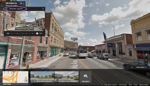
The little clock in the upper-left corner (circled in purple) is the trigger for a time warp. The timeline on at the bottom of the thumbnail photo shows the full range of available imagery, with the white dots across the gray bar indicating where they fit in the 2007-to-present trajectory. Indianapolis was among the first cities featured in Street View, with the first round of photos dating from the summer of 2007 and released in December of that year.
It’s a remarkable chronicle, especially in fast-changing areas that the Googlemobile visits frequently—like Fountain Square. Here’s that same vantage point in 2011, when the Cultural Trail was in the thick of construction.
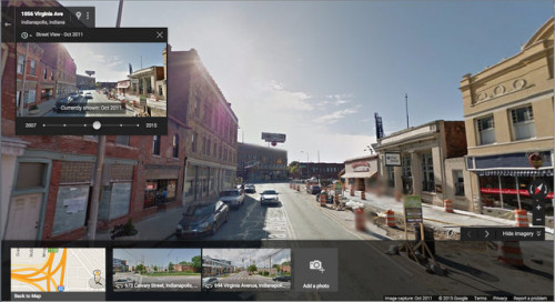
And here’s a perspective in 2007, before this leg of the Trail had begun.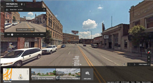
Meander through the local roads of Fountain Square and it’s equally revelatory: while a few of the most dilapidated houses in this old neighborhood faced the wrecking ball, a considerably higher number have enjoyed a sensitive rehabilitation. In some cases, contemporary infill has replaced an older home, or it has occupied a previously long-vacant lot. As this rediscovered neighborhood grows in attractiveness, we can expect to see more redevelopment in successive Google Street View snapshots: a play-by-play account of gentrification.
But far more interesting, in my opinion, is the more checkered evolution of the Bates-Hendricks neighborhood to the southwest. Lacking a commercial corridor like Virginia Avenue, it hasn’t enjoyed the immediate appeal of Fountain Square or Fletcher Place. But its proximity to downtown—particularly the Eli Lilly campus—makes it a prime new candidate for a similar wave of redevelopment and revitalization. At the same time though, the aging housing stock combined with the moderate incomes of most of the households living there also rendered it vulnerable to a wave of foreclosures during the peak of the economic crisis from 2008 to 2011. Lacking the widespread redevelopment interest that Fountain Square has enjoyed, Bates-Hendricks suffered considerable abandonment over the last seven or eight years. So the neighborhood’s current condition is a mixed bag.
Google Street View’s time scroll confirms this. Walk the streets, look at the homes from the most recent Google pics, then compare them to four years ago, and eight years ago. While many homes are enjoying a restoration, a seemingly equally number are going vacant. The City of Indianapolis has initiated demolition proceedings on some of the most blighted properties in the neighborhood—something it only began doing in the last five years or so (presumably because Bates-Hendricks did not have too many vacant properties as recently as the mid-2000s). A few enterprising developers—mostly nonprofit groups—have reclaimed some of the vacant lots and built new homes respectful of the urban architectural vernacular. But, since 2008, I’d wager that the number of vacant lots in the neighborhood has grown, not shrunk. Only in the last two years or so has Bates-Hendricks reached any sort of tipping point, where the curiosity of middle-class investors outstrips the outmigration of long-term working-class homeowners. A recent Indianapolis Business Journal article recognized Bates-Hendricks as the likely “next big thing†in revitalization. Just two or three years prior, such an article would smack of Pollyannaism. But the escalating number of restored homes suggests that the IBJ may be right. Still, the sheer volume of housing in disrepair—or completely vacant—means that, despite the fact that its worst days are probably behind it, Bates-Hendricks still has some hurdles to climb.
Applying the time scroll along East Street effectively shows everything that’s right and wrong about what’s happening in the neighborhood right now. I’m sure that the leadership at Southeast Neighborhood Development (SEND) and Bates-Hendircks Neighborhood Association are intimately aware of the inventory of vacant or dilapidated houses. For the rest of us who are into this kind of thing, it only takes 10 minutes traipsing around, panning a full 360 degrees, then applying the time scroll to see the changes—equal parts abandonment and reinvestment.
One street corner particularly demonstrates how in flux the neighborhood appears at this moment. The southeast corner of East Street and Sanders Street tells it all. Here it is in the most recent Street View:
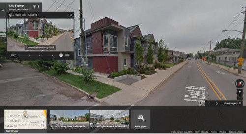
Obviously a new arrival on the scene, and thanks to the fact that a micromanaging historic preservation council hasn’t paralyzed Bates-Hendricks (yet), developers don’t have to worry about architectural conformity. In fact, I reviewed these apartments—known as the East Street Flats—at Urban Indy two years ago, just before they opened.
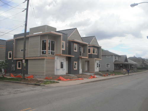
I liked them then, and I still think they’re pretty great—courtesy of SEND. But it’s at least somewhat bittersweet, demonstrated when we use Google Street View to take a step or two back in time. In 2011, the site of East Street Flats was just a vacant lot, along with two vacant twin houses.
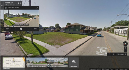
Not much to see here. If, in July 2011, those two homes in the background weren’t yet slated for demolition, they soon would be. But, now let’s go back to the dawn of Google Street View: one of those low-res images from 2007.
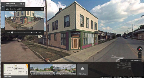
Right at the corner of Sanders and East was a little mixed-use building, probably nearly a century old, with a storefront on the ground floor and one or two apartments above it. It’s no great beauty, and it may have been in unsalvageable condition, though the Street View would suggest otherwise. It goes with out saying to most people who read this blog that this building represented a legitimate contributor to the landscape of Bates-Hendricks with an opportunity for pedestrian oriented retail. And the neighborhood suffers from a dearth of similarly styled buildings.
The East Street Flats that replaced this structure are pretty great: probably higher concentration of residential units than the structures that stretched across these parcels back in 2007. And certainly an improvement over 2011, when the parcels accommodated exactly zero households. But that two-story mixed-use building is virtually impossible to recreate in this day and age. For most of the 20th century, Euclidean zoning, which enforced a strict separation of uses, rendered it impossible. Now people are more sympathetic to it, with most large cities (including Indy…at least sooner or later) endorsing varying degrees form-based zoning that doesn’t mandate separation of uses. Also, most boards of zoning appeals are willing to grant variances to allow such structures in the urban neighborhoods where outmoded zoning regulations still prohibit them. Nonetheless, these modest mixed-use structures rarely get built, because the developers can’t devise a pro forma analysis that generates a return on their investment: small mixed-use buildings these days still need space for off-street parking all too often, and developers can’t risk the likelihood that the storefront area may take a few years to find a tenant. Besides, jumping through the hoops necessary to get a variance is time consuming.
So Bates-Hendricks must depend upon the few commercial structures that remain, most of which dot various corners along East Street. And those little commercial buildings are what elevates it to a pre-war, mixed-use environment—a real neighborhood where people can walk from their homes to shops. That’s exactly the character that has propelled Fountain Square, and the absence of such commercial may hold Bates-Hendricks back. One can only hope that other developers in the future can find the sweet spot that makes commercial buildings work along East Street (or anywhere else). A corner café seems humble, but it is the exact sort of business that Bates-Hendricks needs to intrigue investors, which, in turn, leads to other storefronts…the incremental improvements that may help it cast aside its murky outlook once and for all.
Thanks Eric. Fantastic piece.
I was using Google Street View time warp to look at the corner of Virginia Ave and Stevens St from before and after the Trail. It was amazing to see how much asphalt and concrete were in that area compared to the plantings, short crossings, removed travel lanes, etc of the current set up.
Yes. I love this feature. With the caveat that I hope digital records like this are well-maintained, I am extremely envious of future generations. How cool would it be to take a virtual stroll down your own street or the streets of downtown Indy in, say, 1950?
We are in the process of (slooooowly) redoing our 1920s house in Fletcher Place and one thing I wish I had was historical pictures of it. There are so many things where you can say, “Oh, it likely had this, this, and this feature” but it would be great to know what color it was painted, where the doors/windows/features were on the original house.
It is really great in a city like Indy, where change is so incremental and slow. When you live in it and are involved in it every day, you tend not to recognize some of the significant changes. This allows you to truly see what has occurred, good and bad.
Super-cool use of this technology:
http://www.urb-i.com/#!before-after-2/cp44
http://www.urb-i.com/#!W Georgia Street/zoom/cp44/dataItem-ifx65dcb
Fixed link:
http://www.urb-i.com/#!WGeorgiaStreet/zoom/cp44/dataItem-ifx65dcb
Glad y’all appreciated the article. I guess it’s all the more appropriate to travel through time on Back-to-the-Future Day. I hope in a few years we can be fully optimistic about the economic direction of Bates-Hendricks. I’m pretty sure it’ll be on sure economic footing before we ever have hoverboards.
I agree that Bates-Hendricks needs more retail in order to reach its full potential. Living there, we only have 2 restaurants (sister’s place and indy all night) and only 1 retail spot (village pantry…). I would love to see a pizza place or a cafe. Right now, the selling point of Bates-Hendricks is its proximity to Fountain Square or Downtown.
There is so much potential here that hasn’t been tapped (many vacant commercial buildings)! I will say, there has been a tremendous amount of revitalization in our neighborhood. I have only lived in Bates-Hendricks since June 2015. Each week, I see a new home being worked on. I hope to see this trend continue.
http://advanceindiana.blogspot.com/2015/10/binkleys-held-up-in-front-of-customers.html
We’re famous!
Be careful about drawing conclusions about the usefulness or salvagability of buildings from streetscape photographs. Pictures can be deceiving, as they don’t reveal structural defects or environmental risks. Not all buildings areworth saving, and every city (and neighborhood) derserves the right to evolve to meet the needs of the future.
Thank you for the comments, Newbie. Note that I did say it may have been unsalvageable despite the appearance. And I think East Street Flats are great infill.
But in meeting the needs of the future, most neighborhoods built at a scale to accommodate pedestrians (which Bates-Hendricks certainly is) also take advantage of having a few identifiable small businesses which are also within walking distance. At this point, the majority of the walkable local shops are still in neighboring Fountain Square, upon which Bates-Hendricks’ identity depends. Time will tell if B-H gets some more flavor of its own, but if it continues to “evolve” by replacing mixed-use structures with strictly residential, it not have many opportunities to get the future it needs to stabilize. My hope is that, in the future, organizations like SEND can help partner with the private development of corner parcels along East Street as mixed-use structures…kind of like what SEND was trying for with the Carburetor Lofts in Fountain Square, but didn’t quite get.
I live in Bates Hendricks, and if I remember correctly, the building at East and Sanders suffered extensive damage in a fire, which is why it was torn down and was a vacant lot in 2011. It was after the fire that the plan for the apartments came about.
This was fascinating — your hopes for Bates-Hendricks, as well as the info on Google views. Who knew?