As part of my volunteer work with the Green Line citizen’s advisory committee, I recently attended a meeting which provided updates regarding the study efforts for not only the Green Line, but also the Red Line and Blue Line. By now, if you are one of the many Central Indiana residents following these studies closely, you have seen the latest updates regarding refined routes, potential station locations and the like. I will provide a brief overview of those details here, but I want to spend more time analyzing the finer details of each rapid transit line.
Regular readers will be familiar with Urban Indy’s position on all of these lines as we have dissected and provided input about what we, as an urban focused group, think about the potential for rapid transit through the Indianapolis region and how striking the proper balance between moving people and revitalizing neighborhoods along the way is critical.
At this point in time, it is valid to offer a fresh analysis of the updated details, the potential station locations and whether or not they serve the areas most in need of the benefits that rapid transit offer.
Blue Line
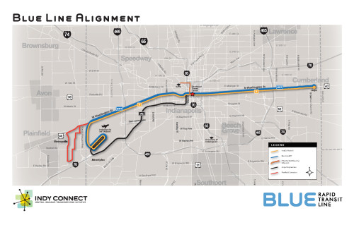
There are no surprises with the Blue Line. Prior coverage has always leaned towards Washington Street being the optimum corridor and while planners have examined trips using 10th street, and the Michigan & New York Street couplet, Washington ultimately ended up on the top of the pile. To that end, this round of refinements (click to open Indy Connect page with maps) offered many station locations. For the most part, they are all logical and really do not offer much room for argument.
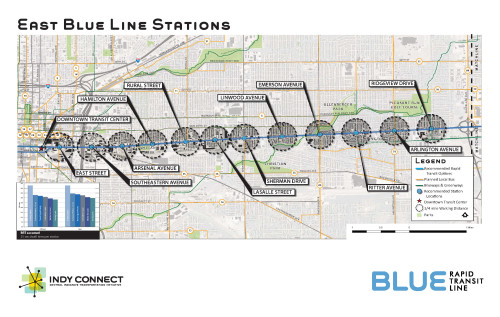
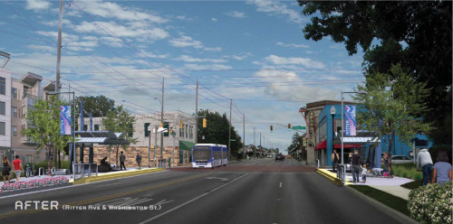
As you can see from the provided graphics, walk-shed (1/4 mile circles around the stations) Â is indicated and for the most part, cover the areas that most of us would think need to be served. The east side receives the lion share of stations along the entire length which makes sense based on existing trip data from IndyGo’s 8. Inside of 465, where a classic street grid exists, stations are spaced nearly 1/2 mile apart providing a walkable environment for nearly all stations. Outside of 465, stations are spaced further apart and this makes sense. If you have ever traveled this corridor, you know that once outside of 465, Washington Street becomes much wider to accommodate automobiles and the associated commercial land use designs. However, this portion of Washington Street is not without transit trip generators as Washington Square Mall and Meijer both possess significant gravity and are some of the major destinations current transit users travel to. Planners included a rendering of the Irvington Area highlighting what a potential stop could look like. While station design was not a specific focus in planning to this point for the Blue Line. I think most would agree that the rendering paints a pretty picture of the potential station area activity that rapid transit could bring to this already thriving area.
As you can see from the plans, the west side also has a number of stations however, they are spaced further apart. The current land uses, much more industrialized, contribute less to the overall success of the IndyGo 8 and the Blue Line planning reflects that. Although station designs would be similar, planners say an operating plan may provide less frequent service. However, those are merely talking points. The maps provided highlight the original plans taking the Blue Line all the way to the airport providing a high quality transit service for travelers.
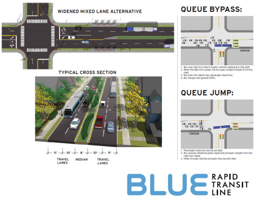
One topic we have covered prior was comparative run time improvements versus the current IndyGo 8. Although printed material does not state it as such, the Blue Line could cover the distance from Meijer on the east side, to the downtown transit center, in approximately 30 minutes knocking a substantial amount of time off of what is today, a scheduled 45 minute trip. This is accomplished in most part via the drastically reduced number of stops. However, additional plans call for que jumping at stop lights to give buses some extra time to get in front of automobiles; think Delaware Street downtown at Washington Street.
Green Line
No significant changes were provided that we do not already know about when it comes to the Green Line. The downtown Indy alignments were reviewed and a better defined range of stations along the line were provided with a notable exception being a slight change to the potential Noblesville station. While final station locations have not been determined, planning continues towards the completion of the Environmental Impact Statement (EIS), required for a federally funded project of this scope, for the Green Line.
At the meeting, significant debate centered on the stations south of Fall Creek and this is valid since there is likely to be only 1 station, at the most 2, in this area. Most community redevelopment professionals would lobby for 2 stations as the resulting impact on the the neighborhood could be a game changer. Long plagued by brownfields and enjoying a small surge of rebound, this area could turn the corner with a pair of rail stations. However, the future remains cloudy for exactly where they may be and we will continue to keep an eye on this as the study moves forward.
Red Line
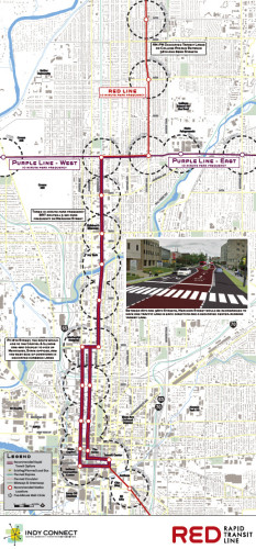
The most exciting news, in my opinion, came out of the Red Line camp. Perhaps some of my excitement is based upon how many possible route options we had leading up to this point in the study. No major changes in the areas were presented. The line is still planned to travel from Carmel to Greenwood via Midtown and Downtown Indy with many stops along the way.
On the north side, there is still some debate on how the line would service the US31 office corridor north of 465. Whether this uses 31 itself, or a combination of College and Pennsylvania to the east remains to be ironed out. However, both would converge on the Carmel City Center. Further south, the line would travel through Broad Ripple with a stop near the new parking garage. Renderings for a potential station were provided and they seem to be contextually sensitive to the area, as you can see by the urban based massing of the station, near where the new parking structure is located. Â One plan offered for handling the buses on College Avenue included a phased parking plan that would operate something like this. In the mornings, parking would be restricted for south bound curb lanes during rush hour providing buses a dedicated space to speed along the route. In the afternoon, north bound curb side parking lanes would be similarly reduced. Whether the entire College Ave corridor would be setup this way, or just signaled crossing areas is still cloudy, however, I applaud this proposal. While it would create some heart ache among residents, it would go a long way towards providing a service that is attractive based on frequent service, and rapid transit times along the corridor. South of Broad Ripple Village, there would be a few more stops before reaching 38th street, including 54th street, 46th street and one at 38th.
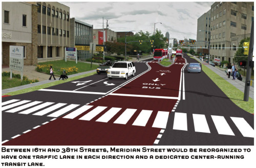
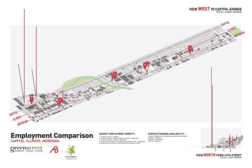
This is where the route gets a bit exciting. The study is still underway, and primary study recommended using the Capitol & Illinois 1 way couplets as travel corridors, but recent news indicates that a dedicated transit-way could be a better choice from 38th to 16th street. Indeed, this is one of Indianapolis’ most transit ready corridors with a vast number of professional employment destinations, Ivy Tech, the Children’s Museum and thousands of apartments and homes just steps away. A preliminary plan for Meridian calls for a dedicated median lane that buses would use to travel north and south. Station orientation is yet to be determined but would most likely be located in the median as well. At 16th street, the transit-way would end, jogging over to Illinois & Capitol where curb-side dedicated lanes would exist. A graphic for this section was provided indicating where jobs were located along this portion of study and the data supports this potential plan.
The idea of a dedicated transit-way is exciting not only for the efficient operations that would result from this design, but also how it reinforces transit as the more efficient means of moving people along this corridor.
South of the downtown transit center, the line would likely utilize Virginia Ave to navigate to Fountain Square. Planners are still working on a route which could bring a station closer to Lilly’s campus but rest assured, it appears that Fountain Square will be the likely path the Red Line travels through. Heading south, the line would use Shelby Ave for points south of here.
One interesting operating scenario in the far south reaches of the Red Line could involve a branching of the line to service medical and job centers. This would cut frequency in half south of where the line branches however, it would still provide a much improved service over what is today, a very lackluster 1 hour frequency service.
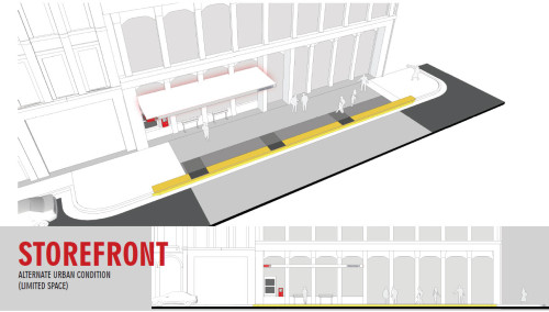
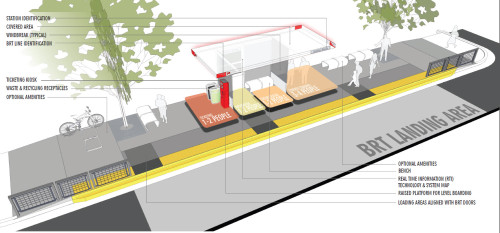
Planners provided a station design guide of sorts. You can see from the provided renderings that a Basic station is planned for most areas which would include standard items such as ticket kiosks, covered seated areas and such. However, some areas with expected higher boarding potential would be rewarded with larger stations including wider overhead coverage areas and perhaps other amenities.
Wrap Up & Other Details

One interesting map that was provided at the meeting was a TOD potential map that combined all 3 routes on a map and indicated what station areas provided the best opportunities for TOD or, Transit Oriented Development. Â The downside of the plans provided to this point is that for the most part, they are transportation plans only. There is no associated land use plan that goes with it. Doing so could be difficult though, and the MPO has hired other consultants to assist with station area planning for at least the Green Line, that I have seen. Whether or not this level of detail exists for the Red or Blue Line yet is unknown. However, the MPO DOES have a TOD guide on their website indicating recommended development patterns. It will be interesting to see going forward how individual municipalities utilize this sort of information. Rezone Indy could be one avenue that Indianapolis uses to push developers into planning transit supportive uses around stations. Indeed, this would be one of the most significant outcomes of these transit lines outside of the actual movement of people.
For the most part, the Red and Blue Lines serve the areas that we here at Urban Indy have been saying need to be served. The job centers on the north side. The College Avenue corridor. Meridian Street, Fountain Square and the east side Washington Street corridor. If the finer minutia can be negotiated properly to allow rapid transit to function as rapid transit should function, then these lines could be head and shoulders above anything else that Indianapolis has ever seen in terms of public transportation.
As always, Urban Indy will keep you apprised as the study moves forward.
Editor’s Note: For full details including high resolution maps, renderings, etc, visit the public meeting material’s page at Indy Connect
Regarding the Red Line heading south from the transit center, I put on my survey that I would prefer to use an alignment that utilizes Madison Ave instead of Virginia.
My secondary reason is that Virginia is just too small to really get the full benefit of BRT since it would be in mixed traffic.
My primary reason though, is I feel Virginia from downtown to Fountain Square would be about the perfect route for a street car. Currently, the walk from downtown to Fountain Square is about 25 minutes which is too far for most people to walk for lunch or coffee or whatever. A street car would be a nice pedestrian accelerator that would help get those that aren’t interested in a nearly hour long round trip walk. The street car would be fine in mixed traffic.
Curt, thank you for putting this together and for your involvement with the project.
I’m in love with this Red Line transit corridor idea between 38th & 16th. Illinois is the “back door” to many Meridian Street businesses, as well as hosting their parking lots . Capitol Ave is largely residential between 38th & 22nd. Transit aside, arguably both Illinois & Capitol would better serve the community by being converted back into two-way streets.
What I like most though is that this transit corridor shows we’re thinking seriously about transit oriented development, not simply adding more and faster buses.
Where are the bike lanes?
oops, meant to post this at the top level
Will there be some type of commuter parking lot on the east end of the blue line? As someone who is in Hancock County it would be nice to grab the Blue Line to work in downtown.
The proposed alignment of the Red Line between 16th & 29th/30th is a horrible idea. The front doors that lead to jobs are skewed to the west of Meridian in that zone. The IUHealth/Methodist Hospital complex stretches one block south and more than 5 blocks north of the “point station” at 16th that purports to serve it.
Further, the one way couplets can be much more easily retrofitted with actual high-speed bus lanes.
And finally, removing rush hour capacity from Meridian will slow the current city buslines there, and will drive a lot of cars over to the one-way pairs…through residential neighborhoods. It may also engender some “not in my front yard” opposition from property owners.
I agree on the need, but vehemently disagree with choosing what I see as the hardest possible way to meet the need.
I asked a question at a recent meeting – “Would IndyGo be able to use the new dedicated BRT lanes?”
Short answer is – there is no answer yet.
> will drive a lot of cars over to the one-way pairs [Illinois & Capitol]
I would expect some of this in many areas of the implementation, not just this transit corridor. I hope IndyConnect is considering these impacts and will produce recommendations accordingly. I’ve heard the idea floated of upgrading alleys along College Ave, for example.
Regarding driving traffic over to Illinois and Capitol, I think that converting them to two-way, as mention elsewhere, would go a long-way toward calming traffic on Capitol, Illinois, and Meridian.
I will throw in my vote for buses on Meridian.
Meridian in that stretch is already the most bus-dense corridor outside of the downtown “bus rodeo” loop. It has 20 minute service most of the day. Take away lane capacity and you just choke the local buses and cars.
Those 30,000 cars per day will go somewhere else if their trip is terribly congested. The “somewhere else” will be the parallel streets.
Calming is fine, but choking is just unrealistic. The mile-wide north traffic corridor from Capitol to College has to handle an expressway’s worth of traffic every day. You can’t START BRT by choking that.
Look…even if BRT achieves a 10% market share, that still leaves 90% of the car trips on the same streets. It is naive and unrealistic to just assume that away.
With the combination of IndyGo 18, 38, and 39 I believe it’s ~10 minutes on average. Still not what I’d consider “bus-dense”.
38 and 39 typically run nose to tail.
The Meridian routing actually does a better job of serving the north end of the Methodist “campus” in that there’s a station at Meridian/22nd commercial and residential node. The Capitol/Illinois option serves nothing between Ivy Tech and 16th because the planners can’t justify a station on that stretch.
There’s a sweet spot for a single stop on Capitol/Illinois at 18th that provides slightly better service to the midpoint of the Methodist complex than 16th/Capitol, while also pretty well serving Citizens Energy and the other offices between 21st and 16th on Meridian (WISH, LWG, WFYI, etc.) both inbound and outbound. All those places are within 0.3 miles, 6-7 minutes’ walk at Capitol, even less outbound on Illinois.
Coincidentally 18th is where the new Methodist tower would be built…if it’s ever built.
That trip time on the Blue Line is a pretty fantastic claim. It can probably be done off-peak. But not at rush.
10 miles at 30 mph is 20 minutes if you don’t ever stop. How can BRT make it from Meijer to downtown in 30 minutes at rush hour, when it must stop and pick up/drop off 12-15 times during its peak ridership time? Unless it’s equipped with one of those emergency vehicle buttons that turns every light green for it…and even then, it seems dubious just because there is always local traffic slowing to turn and entering the street slowly. There is 3 lanes of congestion at Angie’s List in the morning. The route goes past I-465 on/off ramps and Shadeland, too. With traffic calming from the Irvington Streetscape and curb parking in front of Jockamo’s, the section between Arlington and Emerson just always moves more slowly
Making overly optimistic claims for BRT that aren’t going to ring true for people familiar with the routes is not a good way to build a case.
Curt, thank you for putting this together and for your involvement with the project.
I’m in love with this Red Line transit corridor idea between 38th & 16th. Illinois is the “back door†to many Meridian Street businesses, as well as hosting their parking lots . Capitol Ave is largely residential between 38th & 22nd. Transit aside, arguably both Illinois & Capitol would better serve the community by being converted back into two-way streets.
What I like most though is that this transit corridor shows we’re thinking seriously about transit oriented development, not simply adding more and faster buses.
Where are the bike lanes?
Hey, if you guys want to have fun designing street configurations, I just heard about this site on Twitter this morning. Pretty awesome. Share here if come up with some good ones:
http://streetmix.net
This looks like a horrible idea. Streets are for cars, first and foremost, and anything that removes even an inch of roadway for car travel is an awful idea.
Have you seen the disaster that is today’s Broad Ripple Avenue? We need to put that back to it’s correct way, pronto.
The Allisonville Road bike lanes are also an embarrassing disaster.
Most of this idea is ridiculous, as these aren’t “lines,” just bus routes. Nobody likes riding the bus, and very few people ever go to the east side.
Welcome Hoosier! You must be new here.
Streets are for cars, first and foremost,
Except for the entire history of the world up till the early part of the 20th century when they were for pedestrians, horses, kids, vendors, and anyone else who wanted to use them. Roads supposedly belonging solely to cars is a relatively new development in the grand scheme of things.
and anything that removes even an inch of roadway for car travel is an awful idea.
Unless you value things like clean air, safety, social equality, walkability, and transportation flexibility. You would probably be shocked to learn that prioritizing walking, biking, and mass transit actually reduces car-related congestion, in addition to providing all the things listed above (clean air, safety, social equality, walkability, and transportation flexibility.
Pretty sure you’re trolling, but for the record, I like riding the bus. And I have a car and bike and plenty of options to use them both. I like the convenience and it’s cheaper than gas+parking when I go downtown.
Fun fact: IndyGo served 10 million trips in 2012.
I utilize both the Broad Ripple and Allisonville bike lanes to get to/from work, so they are actually very useful. I wouldn’t have a very feasible way to get from Butler-Tarkington to Castleton without those lanes.
A BRT system sucks, flatout! Either build a rail system or don’t waste the time or money.
Just my two pennies!
Another vote to put the Red-Line on Madison. I know FS is hot right now, but if we’re trying to keep transit quick and efficient, trekking through the Square isn’t the way to go. As was said, bring back the streetcar, a little excavating and we could probably (not) reuse the old tracks.