I feel it is time to dispel one of the most common myths about Indianapolis.  I have seen it time and time again, most recently on one of my favorite local blogs Historic Indianapolis.  But I don’t mean to pick on them, as they are not alone in believing that the Riley Tomb marks the highest point in Indianapolis.  A Google search for “highest point in Indianapolis” reveals many such claims.  My favorite instance of this occurrence is this article:
The highest point in Indianapolis lies at Crown Hill Cemetery atop Strawberry Hill (the tomb of famed Hoosier writer James Whitcomb Riley) with an elevation of 842 feet (257 m), and the lowest point in Indianapolis lies at the Marion County/Johnson County line, with an elevation of about 680 feet (207 m).
Variations in elevation from 700-900 feet occur throughout the city limits.
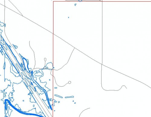
Obviously, 900 feet is a higher elevation than the one given to the Riley Tomb. Â And, the highest point in Indianapolis is actually a bit higher than that, at 914 feet in far northwestern Pike Township. Â The blue contours in this photo are all at 914 feet above sea level, while the red outline indicates the County boundary:
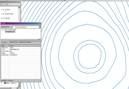
I checked the height of the Riley Tomb, and it showed up as 838 feet in the city’s 2003 contours:
Fortunately, some sources have gotten this correct. Wikipedia mentions that the Riley Tomb is the highest point in the old, pre-Unigov city boundaries, which is a much more careful way of stating it.
I’m sure there are some other long-persistent myths out there of our city. Â What are some others that you would care to share?


Those features you mark out are man-made elevations, if I am not mistaken.
Some are, some aren’t. Regardless, the area is higher in elevation than Crown Hill by almost 100 feet.
Well, just wanted to clarify. lol. Highest place is probably at the southside landfill then. They are constantly adding height to their dirt pile there.
Couple of things to note:
1) The view of downtown from NW Pike Twp is not all that impressive.
2) The “highest point in Indy” claim may date back to pre-Unigov days when the city of Indy did not go all the way to the county line. This seems most likely, IMO.
1. Very true, the Crown Hill view is impressive.
2. That’s correct. Unigov is older than I am, so I think it’s time Indy’s citizens got this right. It’s nitpicky for sure, but I feel that facts should be important.
Incidentally, Dan Wakefield’s classic novel “Going All the Way” refers to Crown Point as the highest point in the city as well. But I guess it was true, back at the time his book was taking place (early/mid 1950s).
Common myth: that Indianapolis is the 12th largest “city” in the country. Kind of goes hand in hand with the highest point/elevation thing in your blog post.
Indianapolis is only the 12th largest city, of course, if we consider by incorporated boundaries–but that’s rarely what people mean, since virtually everything else incorporated by the term “city” carries implicit references to the trade area/metropolitan area. Rarely when we refer to the City of Indianapolis as a measurement of its population and economic influence are we exclusively referring to the Indianapolis city limits. So the number 12 in reference to Indy’s size is very, very misleading.
It’s true the #12 thing is misleading. We’re only 12th if you only consider the population within Indianapolis city limits — which obviously incorporated suburbs that existed before UniGov. If you look at largest metropolitan populations, we’re more like #33 – which seems more appropriate.
Why wouldn’t you include the population in the city limits when you’re counting the population of Indianapolis? It’s not misleading when you’re looking at city populations instead of metro populations.
Maybe it would be better to refer to Indianapolis as the 12th largest municipality in the U.S. since the term “city” is often used to refer to an entire metropolitan area. It’s like when you tell someone in another city that you are from Indy, even though you were born and raised in Greenwood.
I think the biggest example of the 12th largest city statistic being used to mislead people is when many of the transit proponents (of which I am one) complain that we are the 12th largest city with only the 95th largest public transit system. It would be plenty effective to refer to us as the 33rd largest metropolitan area with the 95th largest public transit system, without turning people off by misleading them.
Misleading, only perhaps if someone is a dummy who doesn’t know the difference between the word “city” and “metropolitan area”,” but neither untrue nor a myth (look about the real definition of the word ‘myth” in a dictionary).
For example, it is perfectly accurate to say that Atlanta is the the 40th largest city in the United States and the 9th largest metropolitan area in the country. The boundaries of a city are the boundaries of a city, and the boundaries of a metropolitan area are what they are, too. Indianapolis has had its current boundaries for over 43 years. Would it still be “misleading” to talk about its comparative population size 100 years from now? 1000 years from? The city is the size it is.
Phoenix “proper” covers about 150 square miles more in land area than the Consolidated City of Indianapolis, and Phoenix covered less square miles, say perhaps only the same area as Chicago does, it would logically have fewer people than it does within its present boundaries. But, no one goes around saying it is “misleading” to say that Phoenix is the 6th largest city in the U.S., even though it is only the 13th largest metropolitan area in the country.
If what you really want to do is compare relative densities, or the size of metropolitan areas, etc, then make more precise comparisons, don’t misuse the word “myth” to criticize people who are making accurate statements.
How about the myth of Indy being the largest US city that is not located on a navigable river?
That’s a good one too. May have been true about the same time Crown Hill was the highest point in the city, but not any more.
It’s doubtful that the “inland city” myth was true even at the formation of Unigov. Dallas had 844,000 people in 1970 compared to Indy’s 744,000. You’ve got to go back to the 1940 Census to find Indy bigger than Dallas. By 1960, San Antonio was bigger, though Unigov pushed Indy bigger only for the 1970 Census. Phoenix was bigger by 1980 also.
Despite scientific data proving otherwise, I will continue to tell those who disparage Indianapolis that we are a city that chose to use the highest point in our city limits to bury and honor a children’s poet. That always gives me a moral high ground (but likely not the highest moral ground in the city) from which to argue.
What is the highest point in Indpls. I heard that heading east on Washington st the elevation rises the farther you go. That at Germanchurch rd and Washington st was actually the highest. Just asking