As the public meetings begin to wrap up, I would be remiss if there was not an analysis of the Blue Line. I have formerly reported on the Red Line and Green Line alternatives (click links to read).
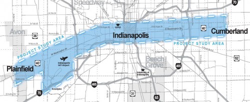
So what is going on with the Blue Line? Right now, alternatives are being measured against one another. At the foundation, is an analysis of the current IndyGo Route 8 service. Currently benefiting from 15 minute headways on a portion of the route, the 8 forms the bedrock of IndyGo’s patronage. It runs back and forth along Washington Street from Meijer on the east side, to the Indianapolis International Airport on the west side.
Blue Line service is scoped to duplicate this route with a rapid service that would provide quicker travel time, frequent service (7.5 or 10 minutes at peak times) and may or may not contain dedicated lanes to accomplish this.

As part of the alternatives analysis, the study team will evaluate everything from alternative routes, possibly on 10th street to different technology. The most likely technology to be applied will be Bus Rapid Transit (BRT). The capital costs of constructing a line are in line with the tax increases being sought by lawmakers at the statehouse. Technology alternatives would include upgrades to current service or light rail. Light rail, I am sorry to report, will likely not make the cut due to the large cost of constructing the entire line; the line would be approximately 25 miles long.

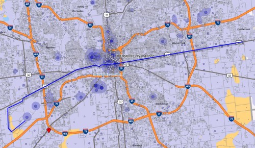
When I explored the Red Line, the basis of evaluation I used was the location of jobs. Indeed, many jobs lie along the Meridian Street corridor, so it is an easy evaluation. However, the Blue Line does not benefit from the same distribution of large job centers along the corridor. Sure, it would converge on downtown and drop riders in the core where the largest density of jobs exist, but outside of that would not serve a tremendous amount of jobs.
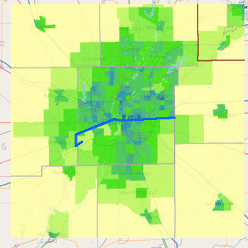
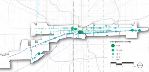
So, why does the current #8 service perform so well? For this, I looked at the latest census results and used the population density maps provided with the study. You can see in the map to the right, (dark parcels being the most dense) that the #8 benefits from riding through the most dense population centers in Central Indiana. As such, Meijer and Washington Square Mall on the east side are among the largest trip generators. This tells us that people are using the #8 to get to the store to pick up the necessities.  Conversely, on the west side, the airport generates a large number of trips as well. Whether this is an indication that airline travelers are using the service or whether workers are using it (FedEx operates a major distribution hub there) is unclear. One this is certain though, it is interesting that some of the largest trip generators in the system are located at the extreme ends of the  route being evaluated.
There may be some that argue that 10th street may also be a good candidate for rapid transit. 10th street also has a large patronage and was recently awarded more frequent service with the upgrades last month. Now, the #10 operates on 20 minute frequency (a boost from 30 minutes). Boarding data also supports this as a number of large trip generators exist on 10th street along the east side as well as the medical district on the near west side.

It will come down to many factors in determining the final route, the technology chosen, and the treatment given. Will the Blue Line operate strictly on Washington Street? I believe any diversion off of Washington Street would only serve to slow down the service offering little advantage over current #8 service. Additionally, light rail would be nice, but there is little money available for this option with the tax increases being asked for at the statehouse. Lastly, dedicated lanes would be nice from a place-making point of view. Having median boarding stations, dedicated lanes and traffic signal priority would go a long way towards declaring to the rest of the region that rapid transit deserves first class treatment. However, a final analysis could determine that dedicated lanes for the entire route may not be needed and that queue lanes at signaled crossings would suffice in offering a service that is truly rapid and improves running time over current service.
Stay tuned! Final alternatives should be available later this year.
It’s comforting (but a bit surprising) to see such density of ridership around Washington Square Mall, given the general decentralization of retail in that area. I’ve always wondered what the reaction would be if a bus route (or even a park-and-ride service) were ever extended all the way out eastward to Greenfield. Do you know if any of the plans have considered such a path?
I believe future planning would come in the form of an express bus along I70 from Greenfield to downtown. Not a bad idea what you have proposed though.
Eric, it’s not surprising to me. I think transit usage around Washington Square is driven by the somewhat diffuse corridor concentration of low-wage retail jobs. The jobs are located well away from inexpensive/dense residential nodes, which are equidistant to the north in Lawrence Twp. (38th to 46th east of 465; note the density there) and to the west in Center Twp. and Irvington.
What I am suggesting is that the trips maybe aren’t so much people shopping as people working there. Time-slices and directions of the boardings might help us to understand usage better.
I ride the 8 once a week from Irvington to just past Wash Sq Mall once a week. From what I’ve learned from on/off and in talking to the drivers, there are a lot that get on the bus on the west side from distribution center shift work. And then there are connections on the east side from the 8 to the East Side connector and I believe 2 other routes that happen at Wash Sq Mall. So that stop is a hub of sorts to get to other places on the east side.
The 15 min increments on the 8 are nice, but they are really only from 7a-7p, so outside of that is still a hefty wait for the bus. And some of those routes on the 15 min variety only go west as far as the zoo.
All in all is much better than before on the 8 route, and BRT would be welcome enhancement.
I think it’s hard to say much about the Blue Line until they actually present a proposal, i.e. will it have exclusive lanes or not and what will the travel times be. Obviously, most of us all in favor of making reasonable investments to provide better transit. But without that info, it’s hard to know how much of an improvement it would provide over local service, and more importantly, how excited we should get about the prospect of this “BRT”.
Curt…Look at the study corridor in the map. It’s not much more than a mile north to south. That might argue for using Michigan and New York for BRT between Emerson and East…it would be close enough to attract “express” users from both 10th and Washington corridors.
Washington really can’t afford to lose two lanes to first-class BRT when it carries 25,000 cars per day. And why put “super buses” on Washington if it’s no different than just upgrading the #8. The same applies to East 10th, for a different reason: it’s already one lane each way. There is no “rapid” transit possible on 10th.
Michigan and New York have enough ROW to each give a dedicated lane to BRT (though it would probably mean taking a parking lane away over part of the distance). Signals are already timed. IMO, that might mean it could be really rapid.
The East Washington Street corridor is “one-sided” residentially out to Irvington because of the parallel rail line just a block and a half or so south. The Pennsy is lined with commercial/industrial uses through the east half of Center Twp. (those uses continue intermittently through Irvington also). So the population density is really north of Washington to Michigan, centered on New York, between the inner loop and Emerson.
As Sheldon Cooper might say, “I’m impressed, Chris. Those are very cogent and reasonable conditions. I reject them all”
And here is why….
I would first go to IndyGo’s board meeting minutes and look back on prior boarding data for the #3 which runs Michigan St. The January 2013 numbers compare as 111k for the #8 and 30k for the #3. Hardly comparable. Even a year ago, January 2012, they were 112k for the #8 and 29k for the #3. Nearly the same difference. I would be apt to support your logic if the numbers supported it.
Next, it would be a jog to get over to NY or Michigan. At the furthest east, you would have to jog (not a good term when trying to provide something rapid) across Emerson which is a lateral move off of the desired route. You might enjoy some efficiencies with traffic flow, but once the bus stops, its going to lose that timed traffic light pattern that motorists driving in enjoy.
Furthermore, nothing is “on the way” on Michigan or New York. Sure, there are some places that generate trip but as it has been concluded already, people are going to places on Washington Street.
Downtown would also present a mess. How are the buses going to quickly interface with the transit center? Back down Penn and up Delaware perhaps, but again, another jog downtown when Washington Street clearly offers an advantage with the straight shot.
As for dedicated lanes, perhaps the studies will conclude that dedicated lanes are not needed to provide BRT on Washington Street. Maybe only portions of it will be dedicated lanes. Cleveland’s HIGHLY successful Healthline only has dedicated lanes for about half of the route. Those lanes have median boarding stations. But once you get a few miles out, they are curbside just like a traditional local bus. The corridor is not unlike Washington Street. Perhaps in some of these areas further from the core, sidewalk boardings like normal will be used but when the buses get closer to the core, and thus the more congested areas and where real opportunities to create a valuable rapid service exist, dedicated lanes have a real valid cause to exist.
I do not support Michigan or New York lanes for this service as I have detailed above.
I think Washington is ideal because there are more destinations there than along New York or Michigan, but it is true that the riders are going to come from north of Washington, at least between downtown and Irvington. It seems unlikely that, given right-of-way constraints and the need to accommodate other traffic, exclusive lanes would be provided on Washington, anywhere west of Arlington and Shadeland. (Also, comparing Route 8 and Route 3 boardings is unfair because service on Route 8 is about three times as frequent as the 3.)
However, I would strongly be against using both Michigan and New York for two reasons. One, it would be inconvenient for passengers, especially tourists and new choice riders to accept going to a different street for their return trips. It just seems really awkward, like the present #3 route. Second, it would just serve to reinforce the idea that it’s acceptable to have high speed traffic blazing through these near-east side neighborhoods that are almost predominantly residential, and where the high-speed, one-way traffic already is highly detrimental to the livability of the adjacent neighborhoods.
I would support exploring putting both directions of the BRT on New York Street, in conjunction with converting Michigan Street to a two-way street and redesigning New York as an exclusive alternative transportation corridor with two-way BRT, a two-way separated bike trail, trees, and sidewalks, with the street closed to private automobiles.
This would help revitalize the existing business nodes along Michigan Street by bringing in traffic in both directions and would put the BRT within convenient distance of both Michigan and Washington. I think the livability benefits to New York Street would be incredible, and it would bring a huge amount of reinvestment to the housing stock along the corridor which is sorely needed. How about that idea?
Idyllic, when I take the subway in other cities, I think nothing of the various entrances being a block apart. Washington DC is a prime example. When I ride the train in suburban Philadelphia, I am dropped off and picked up in different places…usually more than a block apart by car or on foot.
Which is to say, I think you’re making more of the different street argument than is realistic. The riders in the near east side segment aren’t likely to be out of town visitors, they’re likely to be residents who will know the way after their first ride.
Your transit corridor idea is certainly novel for Indy…but:
Pedestrian/transit-only street corridors are probably not any better idea today than they were in the 60’s and 70’s when Minneapolis, Philadelphia, and other cities tried them.
How would small businesses receive their box-truck deliveries (UPS/FedEx)? Where will visitors to residences park? How many neighborhood residents riding bicycles and scooters will get creamed at cross streets and by BRT?
Details, details, details. Don’t sweat those now. If people like the idea, all those issues can be worked out. One lane for local traffic/deliveries could probably be maintained. Maybe even a parking lane. But remember, there are very few commercial properties along New York compared to either Washington, or even Michigan.
And what in the world kind of red herring is your comment about bicyclists getting creamed by cross-traffic? Was that supposed to be a joke? Why would a separated bike trail be any more dangerous on New York Street? Sounds like an argument to ban all the bikes in order to protect everyone.
Regarding your comment about pedestrian/transit only corridors not working, it might be a little apples and oranges to compare trying one as a residential street versus a downtown retail corridor. Nicollet Mall in downtown Minneapolis did lose a lot of retail in the 1990s, but it is thriving now, still as a pedestrian/transit only corridor. Part of this probably has to do with the fact that more residential has/is being built nearby and perhaps because there are more choice riders with more disposable income on the transit system today.
Also, look at Milwaukee Avenue in Minneapolis for an example of a pedestrian-only residential street. It’s only like two blocks long but the real estate values (for very small houses) is much higher than in the surrounding area. The homes are served by alleys and rear parking just like most of the residential that faces New York Street here in Indy.
It can work. Let’s try something bold. 🙂
The comment about cyclists was partly based on creating a false sense of security for riders. There is still a cross-street every block on New York.
It was also partly based on the way we’ve all observed the bike lanes being misused by locals. I see more people riding the wrong way on the bike lanes than the right way. If you’re arguing that a Shelby-type facility might address that, you’re probably right.
If I didn’t hate driving toward downtown on Washington or 10th so much, I’d probably be in favor of your concept. 🙂
Guess I can always use English Ave. even if the speed limit is just 30. 🙂
Alright Chris, I’ll chalk you up as another supporter of the New York Street BRT/Bike/Ped plan. 🙂
I am envisioning a two-way separated bike trail, a bit of hybrid between the Shelby Street lanes and the Cultural Trail. A curb to provide better separation and more permanency, but we can do without the really expensive pavers. Of course, some good trees are a must to shade the trail and protect the asphalt from the scorching summer sun.
Who else is on board?
Curt, I suggest Mich/NY only between East and Emerson, precisely because those are the sensible places to between Washington and the pair…to the Transit Center and Downtown via East, and to Irvington and points east via Emerson. There isn’t much to go to on Washington in that stretch, other than Angie’s List and the Washington Branch library.
I read the “boardings” map as drawing residents to the stops in this stretch, because there’s little to ride TO. And those residents have to be mostly walking south from residences north of Washington. I submit that they would be better served on Michigan and NY for their long rides downtown and to Washington Square.
One might well argue for the line to continue as far as IUPUI on the one-way pair, but I’m not. As you point out, transit center access would be an issue. Also the return to Washington would be a bit problematic west of campus…White River Parkway is less than ideal, and so are the neighborhood streets in Stringtown.