As I have posted about before, the Indianapolis MPO is in charge of transportation planning in our region. Their governing region extends into other counties around the region. A federally mandated charge of theirs, is to keep a long range plan on hand that fiscally constrains our region’s transportation expansion over a 20 to 25 year period. Everything from highway and street planning to transit planning is included. It is updated every few years formally, and informally here and there.  Until recently, there was no transit, at least in large part, included in the plan. That all changed when Indyconnect broke on the scene. Today, the MPO released 3 volumes of draft documents on their website pertaining to the 2035 long range plan. As a transit activist, the most interesting document, was the 3rd Volume named, Transit Vision Plan. You can open the document by clicking here. Its 40 pages long.
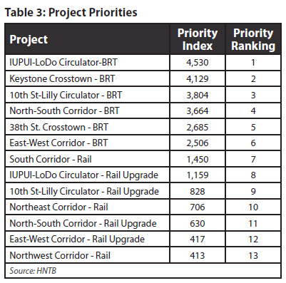
Contained between the covers of this document, are some interesting pieces of information. The document lays out a vision of transit expansion that encompasses a realistic set of projects that could be included within the current 25 year long range plan. The first few chapters capture this in detailed form painting a picture of bus, light rail and streetcar expansion. There is a rating system attached that assigns a value to each potential project and labels it by name. The most surprising appearance, is a system of circulator type routes in the downtown area that are labeled as bus routes that could potentially be switched over to light rail or streetcar technology after the current 25 year plan’s recommendations are implemented. That is where reality sets in, and the most favorable projects are presented; which closely matches the plan announced in November 2010 by Indyconnect, and in which Urban Indy offered some critical analysis of.
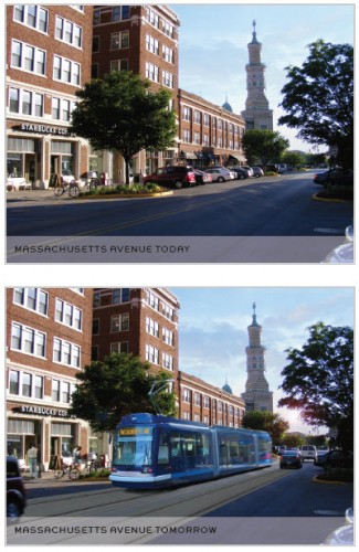
However, the document does provide some hope to local transit advocates that our planning body received the message loud and clear when it came to urban transit improvements. There are renderings included which show streetcar service along Mass Ave in downtown Indianapolis. The highest ranking project on the list of aforementioned projects, is a circulator from lower downtown to IUPUI which would likely be implemented as a bus route and could someday be switched to a streetcar mode of transportation.
There is also significant language included which talks about remediation of Union Station downtown prior to the opening of the first commuter line. The consultants estimated $100 million would be required to fully service Union Station. As I have pointed out REPEATEDLY, there is a need to make this a modern facility that encourages people to want to visit. It makes me smile to know some thought was given to this. There is also space devoted to the remediation of the Belt Railway after the opening of the second commuter rail line; a topic that was touched upon here at Urban Indy recently as well.

Also of note is the downtown transit center that has been much talked about and studied since 2006. In this vision, the planners see a transit center located where the post office facility is located on South Street directly across from Union Station. It would handle 20 buses and facilitate transfer between routes and modes of transportation. There is also a vision of transit spines running north & south on both sides of downtown. One corridor would encompass Capitol & Illinois while the other would use Pennsylvania and Delaware as it’s spine. From each, a branching network of buses would serve the downtown area.
One of the most significant and yet not as visible pieces of the puzzle is touched upon quite often as well, and that is transit supportive land use zoning. Each project would have a check mark of items before coming online of which supportive land use patterns is a part of. This is something we have talked much about at Urban Indy, and which is at the crux of all dense land development.
Conclusions
The picture painted in the plan is quite rosy once totally implemented. While we sit and wait on the state legislature to decide if we should be “allowed” to vote on a tax increase, all of these ideas shall sit and wait. Without any sort of funding, they remain merely a vision and cannot be included in the official adopted long range plan. Without funding, these transit improvements can only be talked about.

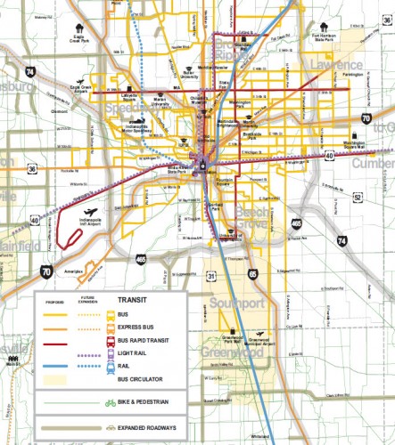
 I will end this with one last thought. If you study the map I have included, you will notice that N/S light rail has been added to the map travelling through Broad Ripple, south along the Illinois/Capitol corridor and to Indianapolis University. This is a logical path for transit in the region which should arguably be included in the near term plan, but is also an expensive project. The last piece to take with us, is that these plans are always under revision, and should public and political sentiment change, or other funding sources be found or created, more capital intensive projects such as light rail could take shape within the current adopted plan. To review the Transit Vision Plan draft version and read the details even more in depth than I have provided, click here.
I realize this is yet another plan, a mandated plan at that. But hearing about updated zoning and landuse to reflect transit is something I have mentioned at every meeting i have been to and online forums i have been a part of. I think this is a major key to the success of transit in indy. In fact it should be the first action taken. at the very least it will create walkable/bikeable communities!
This is the first I have heard of a neighborhood called ‘LoDo.’ Did the MPO make this up? Someone has to put a stop to these rhymes-with-SoHo names!
I’ve heard the name bounced around from time to time including a potential development that was dropped a few years back. Denver also has a LoDo area, but theirs is really a district.
They spell it out in the document the geographic location that positions the line. It’s fittingly called LoDo. It makes sense to me, and really defines an area with little description.
I think that piece to take away, is how high it rates on the list of potential projects.