On October 12, 1492, the first modern Europeans set foot in the land now known as the Americas. We tend to think of urbanism arriving with them. But the truth is that cities rose well before “Columbus sailed the ocean blue”. I wanted to share a few that exemplified the type of urban design happening in Pre-Columbian North America.

We don’t always know very much about these places or the people who built them. But we know enough to give us some important clues about how they lived and what they thought was important. Many of these sites are now protected from threat and open to visitors. These are a great opportunity to go study the evolution of urban form in the Americas.
FROM NOMADS TO CITIZENS
Native American Indians were originally nomadic, but American agriculture began about 5,000 BCE. Agriculture was a big deal, because it allowed dense human settlements. These settlements used similar features because the different cultures shared the same set of technologies and concepts of urbanism. The builders were familiar with other sites and would borrow ideas from the earlier proto-cities.


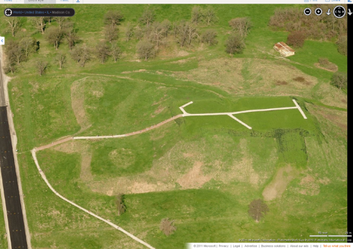
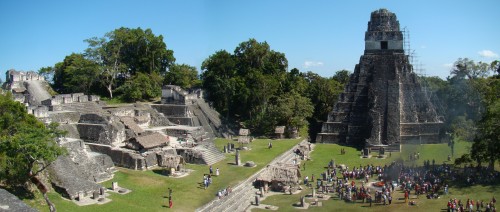
The main architectural style used in these cities involves earthworks or mound-building. You can see in the photos that the earliest mounds were quite small and limited in function. But over time, the mounds became an opportunity for innovation. And so the simple earthen mounds became stone platforms for important structures. In later cities, they became pyramids with stone temples at their top.

The urban form of these cities also changed over time. The earliest settlements used the mound or pyramid structures for sacred rites, but not necessarily as a place to live. But as more energy was invested in the structures, they began to play a larger role in society. And as these sites gained more importance, the builders began formally planning their city centers.

ADENA
Close to the home of Urban Indy is Mounds State Park in Anderson, IN. The Great Mound is a very well preserved ceremonial site built around 200 BCE by the Adena people living here. It is not a city, but I wanted to share it because it offers a glimpse into the cultural technologies that the people in this area would later use to build their cities and create special places within them.

A site this old (over 2000 years) keeps many of its secrets, but the consensus is that the people were farmers and fishermen and used canoes to travel on the river systems. The Great Mound is the central place among a larger complex of mounds, one that forms a solar observatory with solar alignments used to track the course of the year. In effect this was their calendar, but maybe it would be more appropriate to think of it like a clock tower in terms of significance to the people.

There are some key things to be learned from this site. Even 2,000 years ago in the Midwest region, native American Indians are living in stable communities, they are cooperating and investing energy into their infrastructure, and they know how to plan a site so that it becomes more than the sum of its parts.


MISSISSIPPIAN
Just a quick drive from St. Louis is Cahokia Mounds. It is one of the most significant archaeological sites in the US, but it sometimes feels as though few people even know of its existence. It is a UNESCO World Heritage Site, one of only 8 cultural sites in our nation designated as being of supreme importance to the story of human civilization. Estimates suggest that at its peak it was a city of 20,000 residents, and was occupied from the 10th century until the 14th.

What we know from excavations is that the residents built houses or ceremonial structures on top of each mound. Thus the mounds reflected an elevated position in society. But that wasn’t the only purpose, because the mounds and wooden buildings were also used to organize the city into streets, public places, and defensive structures.

The scale of the main mound is massive. It is large enough to pass for a geologic formation, and probably would have been except for its regular shaped sides. But this mound was indeed built by people moving dirt by hand. As such, it’s definitely notable as one of the earliest and largest single public works projects in American History.

A recreated “woodhenge” lies just to the west of the main mound. Not surprisingly, the Cahokia residents needed a solar observatory to track the passing of the seasons. A prehistoric farmer would still need to know when to plant and harvest with certainty, as well as timing the important religious ceremonies held here.

Cahokia is across the river from St. Louis which makes it easily accessible for just about anyone to visit. I recommend visiting often and treading lightly.


There are many mounds in the area, up to 120 special places built for a specific reason that we may never know. Undoubtedly, some have been lost forever to the plow and bulldozer. The parts that remain are an amazing testament to the dedication of these early American urbanists.
PUEBLOAN
The Pueblo group of American Indians have a unique place in American History. Living in cliff dwellings in the canyons or on top of Mesas in the American Southwest, they maintain the communities they founded over 1,000 years ago. No easy feat considering they live in a very dry ecosystem. They responded to their environment in different ways than the farmers of the Mississippi River system, and so you don’t see mounds but structures built into the ground for thermal regulation.
At the height of their ancient civilization, they created a sacred urban center at Chaco Canyon (another UNESCO World Heritage Site) with roads radiating from this central place throughout their territory. What makes their city planning interesting is the amount of thought they put into their buildings. They could track solar movements as well as lunar movements with precision, a good example of their patience and skill.

They developed their own system of civil engineering technology to find ways to store and control the scarce water supplies. Other Pueblo sites include the sky city of Acoma and the World Heritage Site of Taos Pueblo. While some sites are open for visitation, a lot of them feature active communities living in the houses their ancestors built hundreds of years ago. I would have to vote these places as the most sustainable of American communities, by far.


The residents appreciate their privacy, so there are not many photos of modern life in a Pueblo. But you can visit many sites that are no longer inhabited, even some that have been Americanized with the missing handrails and parking lots added. You’re welcome, ancient Puebloans.

MAYAN
In the areas that are now Mexico, Honduras, and Guatemala the people of the Mayan civilization produced many cities, including some that would rival the size of any in Europe at that time. Mayans had a sophisticated society and their cities reflected it. They also had some advanced technology not available “north of the border” including a written language, a numeral system, a corbel arch, and the famous long calendar that could track celestial events across thousands of years.


At places like El Castillo, the Maya built stone temples on top of pyramids. This gave their sacred sites a greater sense of permanence. The stone buildings also have a greater psychological impact, one which is easy to appreciate even a thousand years after original construction.
On the other hand, the Mayans were not as interested in establishing a city plan with grand gestures. Their cities were never very dense, and they did not create strong axes, regular shaped public spaces, or strong streetwalls, at least based on the limited examples I have seen. (and yes please correct me in the comments if I misstate anything)


TEOTIHUACAN
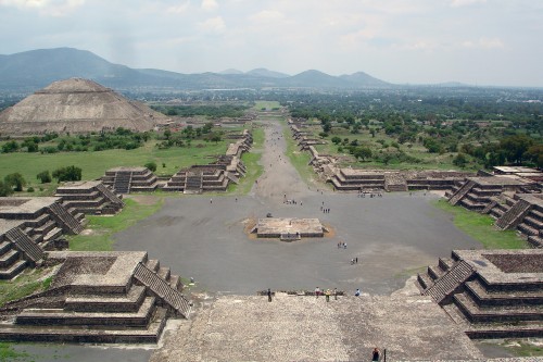
 Teotihuacan is one of the most important sites in central Mexico. This city held over 100,000 residents at its peak circa 600 CE, which made it one of the top 10 population centers in the world at that time. Teotihuacan is famous for the formal planning of its ceremonial center. The buildings were laid out on a strict axis and were remarkable displays of engineering technology and political vision (it’s not easy or convenient to build with perfectly straight lines).

The main avenue was addressed by several temples, pyramids, and public spaces, which establish a street frontage and setback paradigm. On a festival day, the wide paved street could hold many thousands of residents (similar to our urban malls) as well as the people visiting from the surrounding “suburban” villages. The Pyramid of the Sun, halfway along the avenue, is the 3rd largest pyramid in the world. Looking down the street sightline makes it obvious why they were building this way. This place is just flat out amazing.


But the real attraction to this city is the plaza and marketplace in front of the Temple of Quetzlcoatl. It was this marketplace that solidified the city’s significance as the economic and political powerhouse of North America. Like any good public space, people traveled from all over to trade rare goods and perhaps wonder what life was like in the palaces and mansions surrounding the plaza. Teotihuacan eventually was abandoned for unknown reasons, and like Cahokia we know little about the reasons why.
AZTEC
Tenochtitlan was the capital city of the Aztec empire, established on July 18th, 1325 CE. We know a lot about this place because it was the leading power in Central America when the Spanish arrived, and had a population upwards of 200,000 residents. The people of Tenochtitlan had developed a way of farming on a lake, or what we might call aquaponics. This was a very efficient process for growing food, and the dense city became a strong military and economic center. With aqueducts piping in fresh water, paved streets, and a thriving market economy, the city was a marvel to behold for the first historians who visited.

The city is still there and now known as Ciudad de Mexico (Mexico City). With a population of 21 million people, it still the largest city in the Americas. Unfortunately, the war of conquest scraped this city to its foundations so what we see now is a Spanish Colonial layout. Later on the lake was drained to prevent flooding. These facts complicate the study of Tenochtitlan because the historic city center has been built over by modern society.

These examples only scratch the surface of what was going on in Pre-Columbian cities. I think it’s a fascinating topic because there are so many sites in good condition that can be visited. It’s a great way to study how people and crowds relate to public spaces and monumental architecture. I also enjoy seeing how each society has their own style, because they are all revealing a small bit of truth about what we really want in a city.
We are fortunate in Indianapolis to have the Eiteljorg Museum of American Indians and Western Art. It houses a museum of local and regional history as well as contemporary art. It is downtown next to the White River State Park, conveniently located 50 miles downstream of the Adena Great Mound in Anderson.
Nicely done. I’ve been fortunate enough to have visited Teotihuacan, Chichen Itza, Tikal, and Mounds SP. Need to visit Cahokia on my next trip to St. Louis.
anything you want to share from your experiences?
The first 2 were on a class trip to Mexico before my senior year of high school. I climbed the Pyramid of the Sun at Teotihuacan. The heat was too oppressive to do the same at Chichen Itza. My favorite part was the ball court at Teotihuacan, since I was a sports nut. But of course their game was quite different than anything we have today.
I visited Tikal in 2006. Climbed a pyramid and took in the view of the other sites while listening to howler monkeys.
I also visited Chichen Itza in high school. It’s extremely impressive, but the thing that sticks out in my head how unusually steep the main temple/pyramid seemed. This pic from wikipedia is a pretty good exhibit of the stairs:
.
http://en.wikipedia.org/wiki/File:ChichenItzaEquinox.jpg
.
They let you climb on anything and everything down in Mexico and some areas of the ruins are not particularly safe. It’s a lesson on different cultures — if that were in the US, they likely wouldn’t have allowed people to free-climb the temple stairs for fear of being sued if they fell.
Yes, I think the steepness also dissuaded us from the climb.
So far I’ve visited Teotihuacan and some Pueblo ruins. We could easily hit Mounds and Cahokia. Sounds like we have some plans for the future. Thanks for sharing.
It was really fun to do this one, glad it was appreciated. There are mound-builder sites all over the midwest and mississippi river system, so definitely go check some out.
I don’t know how I forgot before, but as a kid (10 years old or so) we went to Effigy Mounds in northeast Iowa. Very interesting stuff.
nice change of pace for UI. Thanks Graeme.
Angel Mounds outside of Evansville is another great example of Mississippian urban culture.
http://www.indianamuseum.org/sites/ange.html
http://floridahistory.com/indiana2.html
Graeme–
Great article. I’m glad you touched on how few people know of the existence of so many of these sites. Obviously they are nowhere near as intact as some of the Mayan sites south of the border, but it does feel as though they’re a missed opportunity in terms of pre-Columbian tourism. Any big tourist campaign would of course have to balance the encouragement of more visitors with guarding against site desecration, but usually an elevated visibility only helps raise awareness and encourage further stewardship.
Many grade schools from Indy would take trips to some of the Adena mounds in southwest Ohio, though I can’t say mine did. Mounds State Park seems almost as overlooked as Cahokia. Compare these sites to the attractions in Central America and they do seem pretty bleak. I’ve been to Tikal like Kevin, as well as Palenque, and in both cases, the nearest towns accommodate swarms of tourists. Is it possible that these Adena and Mississippian sites are just too decentralized and spread out, and too little remains that is of archaeological interest?
One thing is certain. The more iconic the site, the more apt it is to attract tourists. There is something to be said about today’s urban centers and how monolithic sites such as Monument Circle, Empire State Building, CN Tower, Eiffel Tower, etc (I could go on here…) tend to draw people in en mass versus sites that try to sell other less monolithic structures as tourist draws.
.
Some things do not change.
Nice pictures. I really enjoyed your site. But could I suggest you find another term for “Americanized”? That gave me a belly ache 🙂
Before they stopped allowing people to climb El Castillo in Chichen Itza, my father proposed to my mom atop the pyramid on the day of the spring equinox, also known as the day of the serpent shadow. Little fun tidbit.