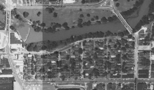
From time to time I like to troll through the city’s aerial photography records and see how the configuration of our city has changed over time. In particular, it’s fascinating and depressing to see the changes that interstate highway construction brought upon our urban neighborhoods. In some cases, the construction bisected once contiguous neighborhoods; in others, construction completely wiped them out. There’s a particular area I’d like to focus on here — a rough rectangle bounded by the Fall Creek on the north, Boulevard Pl. on the east, 21st St. on the south and Dr. Martin Luther King Jr. St. on the west — that is an example of the latter. It was a dense urban neighborhood in 1962:

It’s tough to say for certain due to the low resolution of this photograph, but my finger estimate says approximately 100 homes (and perhaps a couple apartment buildings) once stood on this location. We can only guess, but it might have been a charming neighborhood with access to the Fall Creek for leisure on the north end.
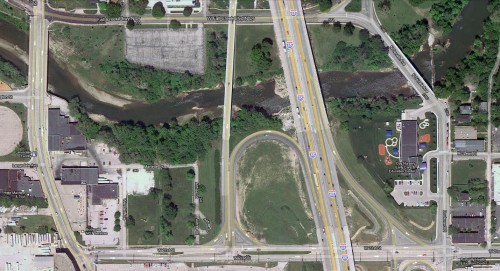
By 1972, construction of I65 and the on/off ramps at 21st had removed all but a handful of houses in this area.

Notice that a number of houses were marooned to the west, boxed in by industrial uses to the west and south and the new interchange to the east. Over time, they were knocked down a couple at a time. Based on the aerial photography records, the last house was removed sometime between 1997 and 1999. On the east side of the interchange, a handful of houses remained until 2003 when IU Health cleared all that land to build the IU Health Day Nursery on that location. Today not a single home stands in this area and it’s difficult if not impossible to get anywhere near the Fall Creek.

Depressing indeed.
Beyond the removal of housing, you didn’t mention the imposition of the parking lot on the north bank of the creek. It serves a church whose former lot is now buried under the southbound 21st St. offramp.
.
Also, the Kessler-designed dam in the first two pictures was removed a couple of years ago, lowering the pool of the creek past the central corridor bridges. It has exposed sandbars and wetlands that are becoming overgrown. Most of the time a concrete box culvert that carries a sewer under the creek is visible from Boulevard through the shallow water; in the 2011 aerial it looks like a dam.
Interesting! I didn’t notice the dam in the aerials and didn’t know it was recently removed. What was the reasoning for removing the dam and lowering the pool? I just looked at the aerials and the dam appears to have been removed between the 2007 and 2008 photos.
.
Was all that work at Boulevard recently related to that sewer line you mention? I never did research why Boulevard’s bridge over Fall Creek was closed for so long, but now that you point that out, I can only assume it was the sewer.
The bridge closure was for sewer work. It may also have included some prep for The Big Dig, the sewer tunnel coming through later in the decade that will drain the combined sewers directly to the treatment plants.
.
Don’t know why the dam was removed. I don’t think it was failing. I suspect that it might have required periodic de-junking, which is not a trivial cost. The south bank there is pretty inaccessible because the land above the bank is part of that factory’s lot.
It is so sad that in modern history, relatively speaking, we could just uproot people from their homes and communities and lives to pave another road. I think this topic is what angers me the most of any urban issues. As I think more and more about it, I realize that this was and still is the biggest social redistribution of wealth campaign I have ever seen. This established neighborhood was torn out for “fair market value” and then millions if not billions of tax payer dollars were thrown into paving a highway that connect a suburb to downtown so people can live further away in somewhat exclusive subdivisions and have a shorter commute time to work. These people in the suburb have gained “proximity to an insterstate value” from the loss of value in the community destroyed by their road. Homes that are left now abut an interstate which is incredible undesirable and lowers their property values. Streets that once connected several communities now dead end into the embankment and create conditions much more condusive to crime. Over time this area becomes so blighted and abandoned that factories and warehouses can by cheap land and run dirty operations near any portion left of the existing communtiy. People who don’t live there or don’t know the situation consider the area dangerous and the stigma runs with the land.
Wow, I really motored on there.
Did I mention that the entire layout for the suburb is subsidized by taxes payed by all residents including those families that were removed from their community?
You’re engaging in some revisionism, Joe. The factories and industrial uses were already there: the coating plant at MLK & Fall Creek, the Sterling pump plant just out of the pictures to the south, the Citizens Gas maintenance yard, which in the 1962 and 72 photos still shows the big gas-storage tank [paved circle in 2010], the ice company, the moving-storage warehouse, etc.
.
The housing there would have been built 1890-1920, when there was no separation between residential and commercial/industrial uses imposed by zoning law. (Indianapolis’ first comprehensive zoning ordinance was in 1921.) And “The Man” just didn’t push “undesirable uses” next to ghettos in 1972. More likely the business at MLK & the creek wanted to expand parking, maneuvering and delivery area (semi trailers weren’t around in 1920) and started buying up its remaining neighbors, just like Methodist Hospital did to the south and east, and just as has been happening for 80-100 years between downtown and 38th Street on both small and large scale.
As a planner, you would be embarrassed for your profession if I showed you some of the old plans in my files that date to the 60’s and 70’s. It was a different world then, and I think it’s more than a bit unfair to judge their plans and standards by modern-day standards. 2011 is as different from 1971 as 1971 was from 1931. In 1931, there wasn’t a car in every household yet. In 1971 it was still less than one per adult resident. Today, aren’t we pretty close to one car for everyone over 21?
Another loss: In the 1962 photo, there appears to be a walking path on the north bank of Fall Creek. In the 1972 photo it’s visible but run down, and by 2011 it appears to be completely gone.
That would be George Kessler’s original Fall Creek Trail. Lasted 60 years or so.
Perhaps better to title it the “prolonged dirty sweep”, because the homeowners who didn’t get initially bought out, were probably the bigger losers. In hindsight, it would’ve obviously been better to seize (at fair market value) all the residential properties between Boulevard and MLK in the beginning, but maybe that was proposed and most owners objected. It’s interesting to see all the changes to Fall Creek and wonder what role I-65 played. Did the apparent walking path get abandoned because the interstate noise made it an unenjoyable place to walk, or were just not enough people left in the area to use it?
I was surprised to find the dam removal was well documented. I don’t recall any news of it as it occured. It evidently was spawned by the efforts to fix the sewer/overflow problems in the county. I do recall a multi-million sewage holding tank being installed underground along the White River next to the Track and Field Stadium. The dam must have been removed as part of that project given they happened at about the same time.
http://5citiesplus.org/docs/presentations/T1-3_Fall_Creek_Siphon_and_Lift_Station.pdf
http://www.indygov.org/eGov/City/DPW/Environment/CleanStream/Projects/Documents/18028BoulevardDamFinalwh.pdf
http://www.trva-tcwc.org/wp-content/uploads/2011/10/TPG-Green-5-5-PPT.pdf
Looks to me as if removal of the dam may have led directly or indirectly to the sewer failure problem a couple of years later.
FYI – somewhat related to this topic; there is this Brazilian documentary called Elevado. I haven’t seen it, so if anyone knows where to get it (w subtitles), please advise. Apparently, the film captures the changes that came with the highway that runs through center of Sao Paulo. Fast forward several decades later, and the city’s urban development chief talks about demolishing it (although unlikely in the near term).
Seattle is in the process of burying their waterfront viaduct.
http://www.wsdot.wa.gov/projects/Viaduct/
.
Vancouver is working on tearing a pair of theirs down.
http://www.ctvbc.ctv.ca/servlet/an/local/CTVNews/20110721/bc_vancouver_viaducts_110721?hub=BritishColumbiaHome
.
Here is a good article from Tim Lee about I95 in Philly.
http://www.forbes.com/sites/timothylee/2011/11/15/the-case-for-tearing-down-urban-freeways/
A lot of this could’ve been prevented if more highways were constructed below grade.
I’ve mentioned many times around here, but Fountain Square pretty much survived to be the neighborhood it is today simply because Virginia Ave went over the interstate instead of under it.
As an heir to a family that has been in this community for the last 80 + years, I am saddened by what this freeway and other man made development (for the sake of progress ) has done to this community in particular. Yes it is true that this community was once contiguous with resident populations now west of the freeway. So what we see as a result is the deterioration of once thriving business corridors such as Martin Luther King, as well as a mindset that naturally divides those west of the freeway from those east of the freeway. In developmental planning, I have not seen definitive plans that address re-unifying areas now divided, post infrastructure implementation. This TIF bond cash in that we now see on MLK stops well short of what needed to be done many years ago.
What’s interesting is that indianapolis was following suit with the mistakes that New York and Chicago were making in building these interstates into the middle of the city. Read “The Power Broker: Robert Moses and the Fall of New York” and you can see where a lot of these terrible “urban renewal” ideas came from.
Proof that New York and Chicago shouldn’t be our guiding lights when it comes to urban planning initiatives.