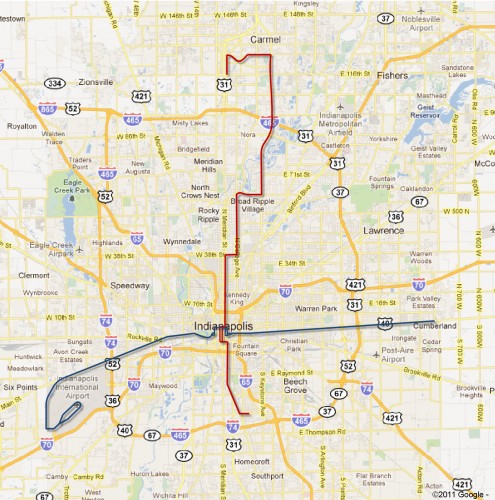
I reported a couple of weeks ago that Indianapolis had received a grant from the FTA to study “bus rapid transit” on the central corridors comprised of Washington Street east/west and some combination of streets north/south from Carmel, through downtown to the University of Indianapolis on the south side. This post attempts to explore the possible routes a bit more and to add some context.

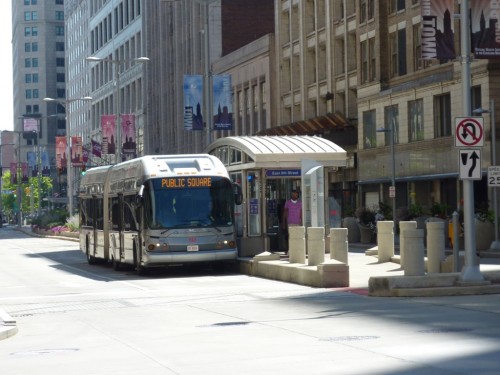
 A look at the Indyconnect site (as of November 1st, 2011) tells us that the proposed BRT (Bus Rapid Transit) routes would be implemented in the short term, relatively speaking, with possible change over to light rail transit years down the road. 10-15 minute headways during the day with larger headways off-peak would be the supposed service level. Signal priority for buses approaching stop lights would be given and it is possible that in some stretches, the buses could get exclusive right of way or passing lanes or both. Enhanced passenger stops with lights, benches, real time arrival data and other rider amenities would be built along the corridors to enhance the service to nearly the standards one could expect with light rail.
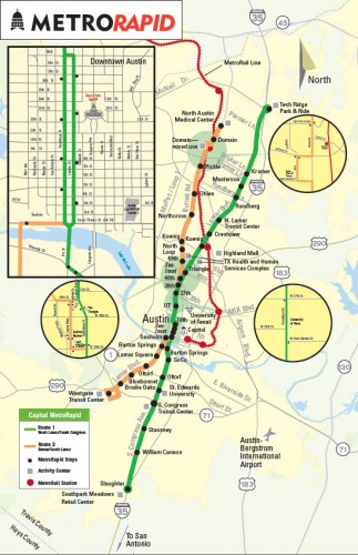
I look at a lot of systems being developed around the country from light rail, subway, rapid bus, etc and in Austin, Texas, a similar project recently received funding to begin construction. In Austin, two corridors were packaged under one proposed project to the FTA essentially green-lighting two separate corridors under one approval process. This surprised, but pleased me. In one fell swoop, ridership would be improved upon two long corridors. Revenue service is scheduled to start there in 2013 after all stop facilities are built and new new buses are purchased.

The Austin system is worth comparing to Indy because they took a nearly identical approach that Indy is taking. Different looking buses. Improved stops. Pick-up & drop-off permitted only at scheduled stops and the fact that service is focused along routes that have high existing demand. Additionally, this service can be implemented relatively cheaply. The 37.5 total miles in Austin is costing a total of $47 million. This includes all construction costs as well as purchase of buses. Comparative light rail service would cost in the billions for that many miles worth of service.

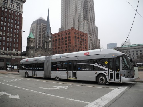
In Indianapolis, we are just now starting the process of studying alternatives for the two corridors chosen. Austin submitted their proposal in the summer of 2008 and was awarded the last of the funding in the summer of 2011. This summer, the Indyconnect team brought one of the vehicles from Cleveland to display at the State Fair. It is assumed that longer, more specialized buses such as these would be used here locally. I took a stab at the routes on the map at the top of this post. The north/south route appears differently than what you would find on the Indyconnect map and looks like a combination of the College Ave route and the Keystone Ave route. This is because I found the description in the FTA document (which I used as the defining langauge) to be different from the proposed routes on Indyconnect’s website. Whatever the case, it makes perfect sense for a route to start in Carmel, and travel to downtown area via Broad Ripple and the Meridian Street corridor. These are all job centers and as I have repeatedly pointed out, ROUTE MATTERS when choosing how to spend scarce transit dollars. It makes little sense to start a route in Carmel and send it to the southside without ever travelling through downtown. It also follows closely along the route I have suggested for Broad Ripple light rail.
We can argue until we are blue in the face about which mode, bus or light rail, attracts the most ridership, stimulates dense urban development and rebuilds neighborhoods. In the short term though, great service could be implemented and grow transit share while planning for a more robust rail line down the line. The presence of beefed up stops and the promise of more reliable service through limited stops and real-time arrival data will greatly improve the transit service along these corridors which are already well healed transit corridors.
11/4/2011 Editor’s Note: I received the following imformation regarding this from the Indianapolis MPO this week and thought I would add it to this note.
In the early phases of the Indy Connect plan, we were doing a lot of planning and analysis for the entire region. While Keystone was represented as the north-south corridor serving Carmel it was noted during meetings and always the intent to do an alternatives analysis to determine the best north-south route. That could be Meridian, College, Keystone, etc.  The new grant will allow us to fully vet a N/S corridor through the Alternative Analysis process. The AA would position us nicely for a potential Small Starts or Very Small Starts application.
That southern stub shouldn’t follow Madison. It should follow South to Virginia to Shelby (or South to East to Morris to Shelby). Otherwise it bypasses the heart of Fountain Square, Fletcher Place, and Garfield Park, which are densely populated (and destinations) on the way to U of I.
Also major activity centers in Fountain Square. I would call Fountain Square a great transit ready area with all the entertainment going on there as well as the apartments going up all the way down Virginia Ave.
Yep. ROUTE MATTERS! Employment and activity centers matter more than following a “path of least resistance”, which is how I’d describe the existing rail corridors to Fishers and along Madison.
Is that hitch in the Washington line to bring it up to Ohio really necessary? Are they just trying to get rapid transit right to the front door of One Indiana Square, Chase Tower and OneAmerica? I don’t think there’s a enough benefit there to outweigh the logistical issues with light priority to get a bus/train through all those turns in downtown. Yes, route matters, but also SIMPLIFY. Send it straight through on Washington/Maryland. If we can’t get people to walk two or three blocks from stations on Washington/Maryland to towers on Ohio, then I think we’ve got bigger issues.
I took that from the IndyGo COA file that showed future routes jogging up and over like that. I agree with you completly that simply running it straight through on Washingotn/Maryland makes the most sense. Less turns, increases the sense that you are gettingn somewhere faster and as you pointed out, if people cant walk a few blocks we have bigger issues. Im sure people walk further from their parking garage at times.
Likewise 38th. I think it would be a little better to continue on College down to Fairfield/34th, then across to Meridian or to Capitol/Illinois. Same number of turns, but far less complicated to drive. It does sacrifice the office-cluster at 38th & Meridian/Penn/Washington, but again…those are walkable from either 38th & College or from 34th. I also think that Capitol/Illinois is the better routing through the near northside and into downtown. Serves The Children’s Museum and Methodist directly; both are major destinations.
Wow, I thought that lasts image was Indianapolis at first. Is it just me? Bank One tower in center, First Indiana to its left, and at the right, top of the AUL building sticking up behind the Federal courthouse.
(I last lived there in 2001, so those are the only names I know them by.)
I live here and it took a second look to write it off. Even the M&I Bank building……